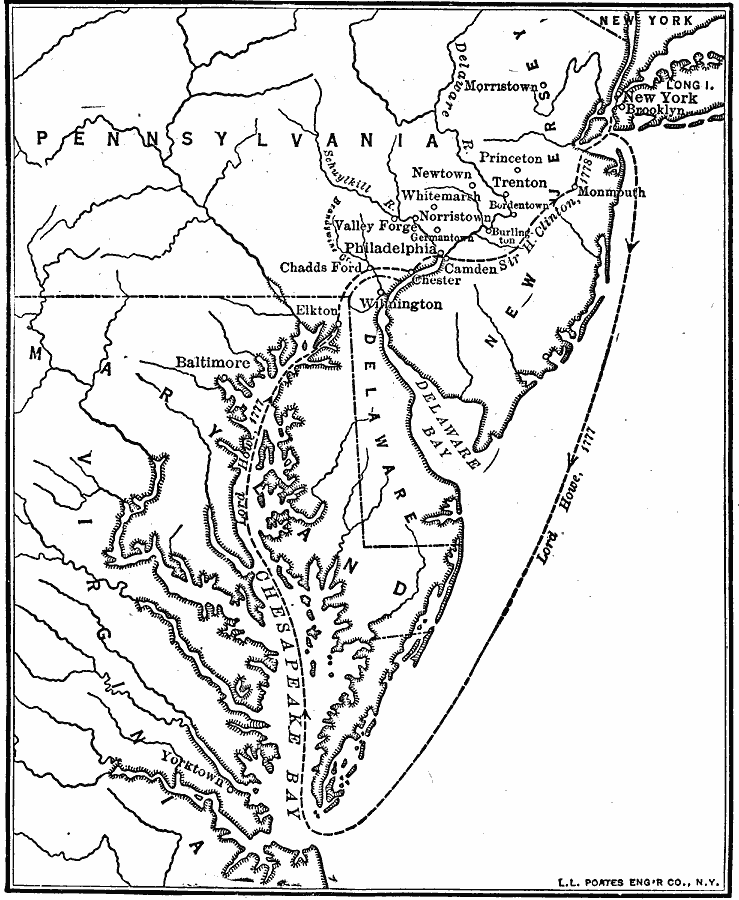
Description: A map of New Jersey, Pennsylvania, Delaware, and Maryland showing the Philadelphia Campaign route(1777) of British commander General William Howe from Long Island to the Chesapeake Bay, his landing site at Elkton (Head of Elk) Maryland, Chadds Ford (Battle of Brandywine), Philadelphia, Germantown, and Washington's winter quarters at Valley Forge. In Philadelphia Howe was replaced by Sir Henry Clinton, who abandoned Philadelphia in 1778 in a march to reinforce the British in New York City. The battle site of Monmouth, New Jersey, is shown on this map.
Place Names: Early America 1400-1800, Philadelphia, �Trenton, �Delaware, �Pennsylvania, �New Jersey, �Maryland, �American Revolutio
ISO Topic Categories: transportation,
oceans,
location,
inlandWaters,
boundaries,
intelligenceMilitary
Keywords: Howe's Route to Philadelphia, physical, �political, �transportation, �historical, kAmericanRevolution, physical features, major political subdivisions, water routes, American Revolution, transportation,
oceans,
location,
inlandWaters,
boundaries,
intelligenceMilitary, Unknown, 1777
Source: Robert Hall, Harriet Smither, and Clarence Ousley, A History of the United States (Dallas, TX: The Southern Publishing Company, 1920) 156
Map Credit: Courtesy the private collection of Roy Winkelman |
|