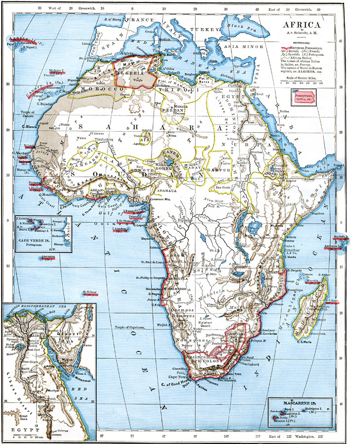
Description: A map of Africa in 1876 showing native African States and European possessions of Britain, France, Spain and Portugal prior to the Berlin Conference of 1885. On this map, European possessions include Algeria, Cape Colony, Griquala Land West, Orange River Republic, Caffir Land, Transvaal, and the coastal areas of Zulu Land, Sofala, Mozambique, Sierra Leon, Ashantee, Congo, Angola, Benguela, and Mossamedes. The African States include Morocco, Tunis, Tripoli, Fezzan, Egypt, Nubia, Air, Masina, Bambarra, Gandoa, Liberia, Ashantee, Dahomey, Sokoto, Bornu, Kanem, Bagirmi, Waday, Adamaua, Dahfur, Kordofan, Abyssinia, Shoa, Adian, and Zanguebar. The names of African Tribes are shown in italics, and include the Tuaregs, Tebus, Jolafs, Mandingos, Fellats, Niam-Niam, Gallas, Somalis, Balanda, Makololo, Matebele, Ovampos, Damaras, Namaquas, Bechuanas, and Bushmen. Major cities, rivers, lakes, and mountain systems are shown, as well as islands under European control. Inset maps detail the Mascarene Islands, Egypt, and Cape Verde Islands. An outline map of Pennsylvania is included at the same map scale to show the comparative area size relationship.
Place Names: A Complete Map of Africa, Egypt, �Tripoli, �Algeria, �Morocco, �Darfur, �Waday, �Kanem, �Bagirmi, �Bornu, �Sokoto, �Masina, �Bambarra, �Gando, �Guinea, �Cape Colony, �Madagasca
ISO Topic Categories: boundaries,
inlandWaters,
location,
oceans
Keywords: Native Territories and European Possessions in Africa, physical, �political, kAfricanNativeStates, kBerlinConference, kComparativeArea, physical features, country borders, boundaries,
inlandWaters,
location,
oceans, Unknown, 1876
Source: A. von Steinwehr, Eclectic Series Intermediate Geography (Cincinnati, Ohio: Van Antwerp, Bragg and Co., 1877) 84
Map Credit: Courtesy the private collection of Roy Winkelman |
|