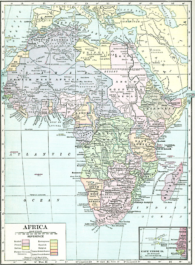
Description: A political map of Africa in 1920 showing colonial possessions of the British, French, Italian, Portuguese, Spanish, and Belgians, including the former German colonies, lost after WWI, per the Treaty of Versailles. This map also shows the Caprivi Strip, a strategic corridor linking the former German Southwest Africa to the Zambizi River in what was then Rhodesia, and thereby access to the west coast of Africa and the former territory of German East Africa. The map also shows Tripoli subtitled Libia Italiana, referring to the Italian claim to the former Ottoman provinces of Tripolitania, Fezzan, and Cyrenaica after the Italo–Turkish War in 1912. The map shows major cities, rivers, and landforms, and an inset map of the Cape Verde Islands under Portuguese control.
Place Names: A Complete Map of Africa, Madagascar, �South Africa, �Somalia, �Egypt, �Nigeria, �Algeria, �Tripoli, �Morocco, �Tunis, �Belgian Kongo, Caprivi Strip, Libia Italiana, Tripolitania, Fezzan, Cyrenaica
ISO Topic Categories: boundaries,
oceans,
location,
inlandWaters
Keywords: Post-WWI Africa, physical, �political, kBerlinConference, kVersailles, physical features, country borders, boundaries,
oceans,
location,
inlandWaters, Unknown, 1920
Source: , Hammond's Modern Atlas of the World (New York, New York: C. S. Hammond and Company, Inc., 1920) 50
Map Credit: Courtesy the private collection of Roy Winkelman |
|