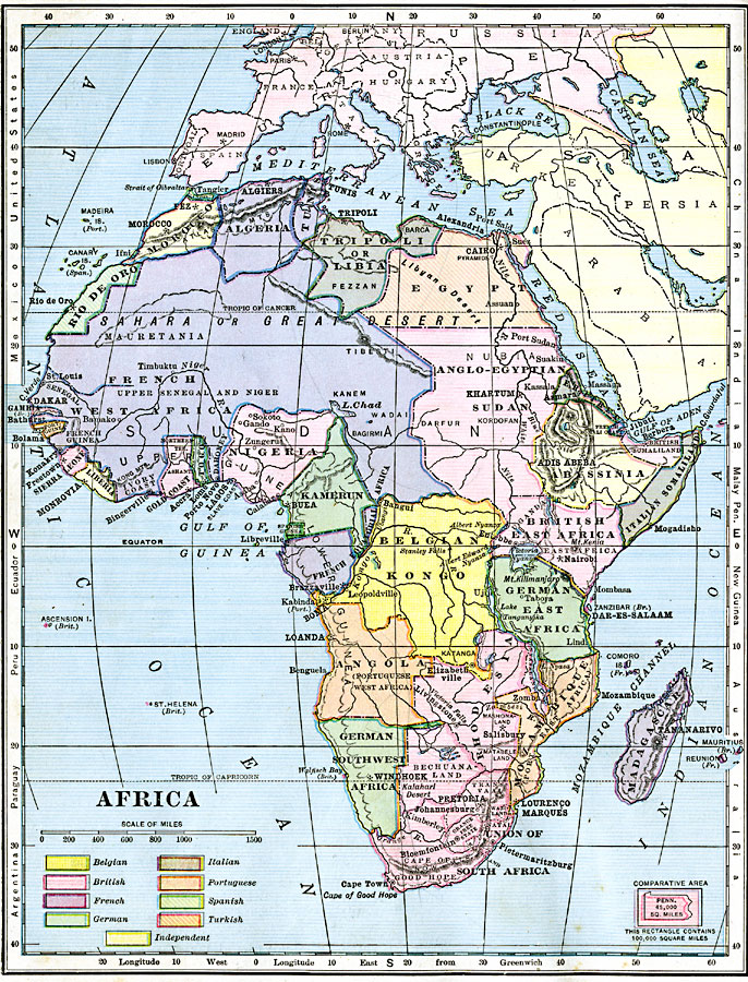
Description: A map of Africa after the Berlin Conference of 1885, which established the European colonial territory claims on the continent. This map shows the Belgian, British, French, German, Italian, Portuguese, and Spanish claims, and the Turkish claim to Egypt. This map also shows the Caprivi Strip, a strategic corridor linking German Southwest Africa to the Zambizi River in what was then Rhodesia, and thereby access to the west coast of Africa and the territory of German East Africa. Capital and major cities are shown, as well as major rivers and landforms. Comparative latitudes for western hemisphere continents and countries are shown on the left-hand edge of the map, with the eastern hemisphere on the right-hand edge. An outline map of Pennsylvania is included at the same map scale to show the comparative area size relationship.
Place Names: A Complete Map of Africa, Algeria, �Egypt, �Madagascar, �South Africa, �Nigeria, �Sudan, �Belgian Kongo, �Abyssinia, �Italian Somaliland, �Tripoli, �Libia, �Kamerun
ISO Topic Categories: boundaries,
location,
inlandWaters,
oceans
Keywords: European Possessions of Africa, physical, �political, kBerlinConference, kComparativeArea, physical features, major political subdivisions, boundaries,
location,
inlandWaters,
oceans, Unknown, 1906
Source: Alexis Everett Frye, Frye's First Steps in Geography (Boston, Massachusetts: Ginn and Company, 1906) 132
Map Credit: Courtesy the private collection of Roy Winkelman |
|