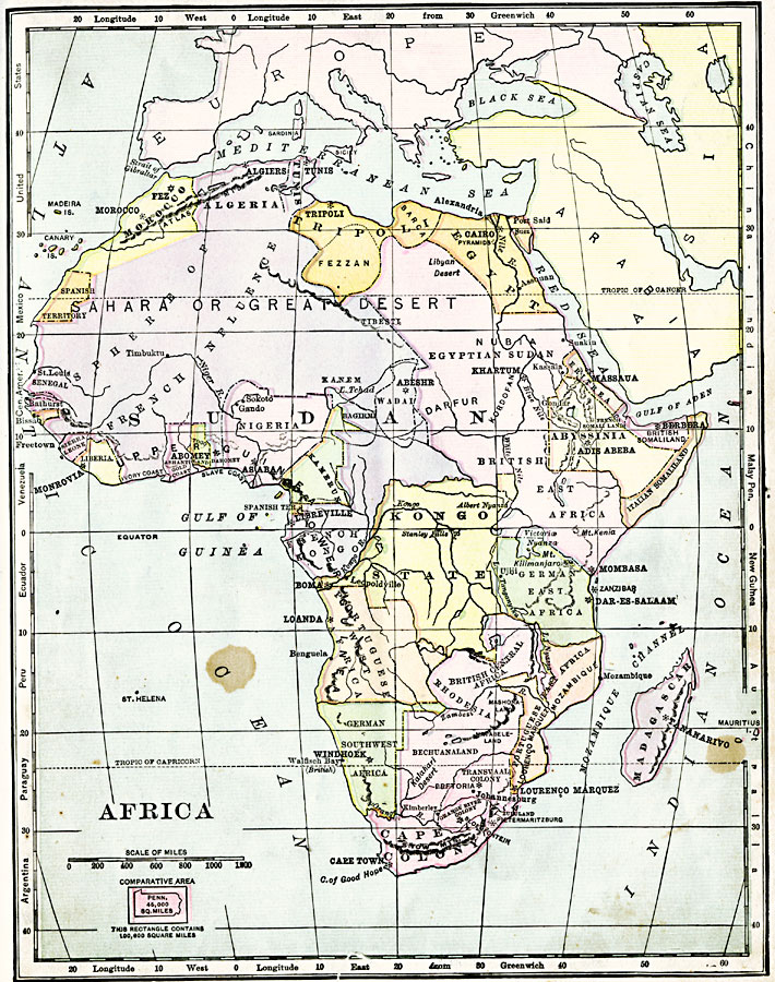
Description: A map of Africa shortly after the Berlin Conference of 1885, which established the European colonial territory claims on the continent. These European and independent boundaries include Algeria and the Saharan Sphere of French Influence, Tripoli, Egypt, Egyptian Sudan, Eritrea, Abyssinia, British and Italian Somaliland, British, German, and Portuguese East Africa, Madagascar, British Central Africa, Rhodesia, Bechuanaland, the Transvaal, Orange River and Cape colonies, German Southwest Africa, Portuguese West Africa, Kongo State, French Kongo, Kamerun, Spanish Guinea, Nigeria, Dahomey, Togo Land, Ashanti, Ivory Coast, Liberia, Sierra Leon, Bissao, and the Spanish Territory. Capitals and major cities, rivers and mountains are shown. Comparative latitudes for western hemisphere continents and countries are shown on the left-hand edge of the map, with the eastern hemisphere on the right-hand edge. An outline map of Pennsylvania is included at the same map scale to show the comparative area size relationship.
Place Names: A Complete Map of Africa, Algeria, �Egypt, �Nigeria, �Madagascar, �Morocco, �Tripoli, �Abyssinia, �Cape Colony, �Kongo State,
ISO Topic Categories: boundaries,
inlandWaters,
location,
oceans
Keywords: Colonial Africa, physical, �statistical, �political, kBerlinConference, kComparativeArea, physical features, country borders, industry, boundaries,
inlandWaters,
location,
oceans, Unknown, 1904
Source: Alexis Everett Frye, Elements of Geography (Boston, Massachusetts: Ginn and Company, 1904) 101
Map Credit: Courtesy the private collection of Roy Winkelman |
|