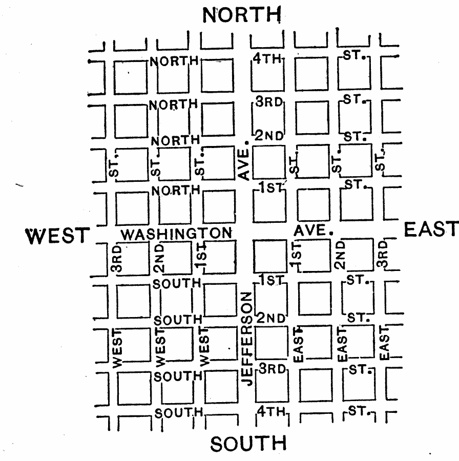
Description: A 1910 drawing of a typical city plan, used to illustrate the need for latitude and longitude. "In a study of geography, it is often necessary to locate places exactly. This is not so easy as it might seem. For instance, suppose we wish to state where London is situated; how could it be done? Of course, by taking a long time, it would be possible to describe the general location of this city; but some more accurate way should be found. The difficulty is much the same as that which arises from locating a place in a large city, where there are thousands of houses. [...] A very simple means has been found for locating city houses. For example, a street running east and west may be selected to divide the city into two parts, as Washington Avenue does in Figure 286. Any place north of this street is spoken of as being on the north side; any place south of it as being on the south side. The streets to the north of this central street are numbered as North 1st, North 2d, North 3d, etc.; those to the south of it as South 1st, South 2d, South 3d, and so on. [...] But we also need to know what part of North 4th Street this house is to be found. To answer that question, another street running north and south, and crossing the east and west ones, may be selected to divide the city into east and west parts. In Figure 286, Jefferson Avenue is such a street. [...] Then if a man lives on the corner of North 4th and East 3d streets, we know not only that his home is north of a certain line, but east of a certain other line. [...] Thus the house can be located exactly. Places upon the earth are located in much the same manner as in the city just described. The equator, which extends around the earth midway between the poles, corresponds to the dividing street (Washington Avenue) that runs east and west." — Tarr, 1910, pp 202-203.
Place Names: Map Drawing,
ISO Topic Categories: transportation
Keywords: Naming Streets as Illustration of Latitude and Longitude, streets, �transportation, roads, transportation, Unknown, 1910
Source: Ralph S. Tarr, B.S., F.G.S.A. and Frank M. McMurry, Ph.D., New Geographies (Second Book) (New York , NY: The MacMillan Company, 1910) 202
Map Credit: Courtesy the private collection of Roy Winkelman |
|