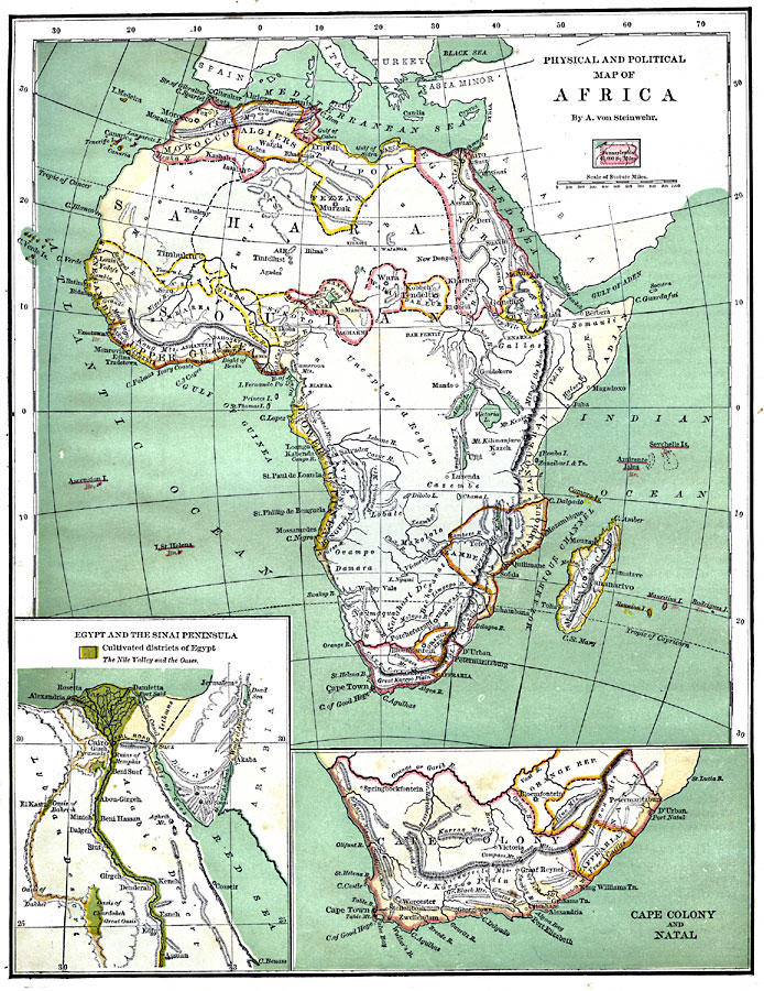
Description: A physical and political map of Africa prior to the Berlin Conference of 1885, which established the European colonial territory claims on the continent. This map shows the African states of Morocco, Algiers (Algeria), Tripoli, Egypt, Nubia, Abyssinia, Dar Fur, Waday, Bornu, Sokoto, Gando, Masina, Senegambia, Sierra Leon, Liberia, Upper Guinea, Lower Guinea, Zambesia–Mozambique, Zanguebar, and Madagascar, and the European colonies of Natal, Caffraria, Orange Republic, and Cape Colony. Two inset maps detail the Cape Colony and Natal, and Egypt and the Sinai Peninsula, including the Suez Canal and the cultivated districts of Egypt. An outline map of Pennsylvania is included at the same map scale to show the comparative area size relationship.
Place Names: A Complete Map of Africa, Egypt, �Nubia, �Abyssinia, �Darfur, �Tripoli, �Algiers, �Morocco, �Soudan, �Guinea, �Cape Colony, �Mozambique, �Zanguebar, �Madagasca
ISO Topic Categories: boundaries,
inlandWaters,
location,
oceans,
transportation
Keywords: Pre-Colonial Africa, physical, �political, kAfricanNativeStates, kBerlinConference, kComparativeArea, physical features,
topographical, country borders, boundaries,
inlandWaters,
location,
oceans,
transportation, Unknown, 1870
Source: A. Von Steinwehr, Intermediate Geography (Cincinnati, Ohio: Wilson, Hinkle & Co., 1870) 78
Map Credit: Courtesy the private collection of Roy Winkelman |
|