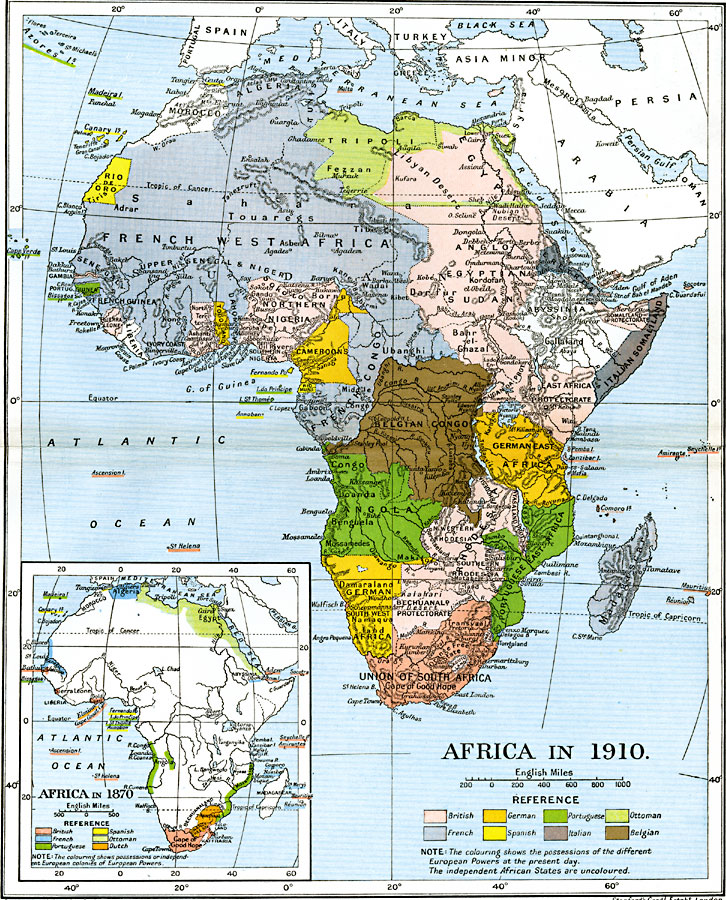
Description: A map showing the European colonization of the African continent before and after the Berlin Conference of 1885, when the most powerful countries in Europe at the time convened to make their territorial claims on Africa and establish their colonial borders at the start of the New Imperialism period. The inset map shows the continent in 1870, prior to the conference, when the European sphere of influence was restricted primarily to narrow areas along the coasts, the southern areas near the Cape of Good Hope, and the northern areas of Algeria and Egypt. The inset map highlights the strategic territorial claims of Europe in Africa for trade and naval strength, as with the British claims on the Strait of Bab-el-Mandeb between the Red Sea and the Indian Ocean and the colonies at the Cape of Good Hope, and the Spanish claims at Tangier on the Strait of Gibraltar. The map also shows the Ottoman claims along the Mediterranean and Red Sea from Tripoli to the Strait of Bab-el-Mandeb. The two independent African States shown on the inset map are Kaffraria and Zulu Land at the southern tip of the continent. The main map shows the continent in 1910 with the British, French, German, Spanish, Portuguese, Italian, Belgian and Ottoman colonial boundaries established, and the only independent African States being Abyssinia, Morocco, and Liberia.
Place Names: A Complete Map of Africa, Algeria, �Congo, �Egypt, �Ethiopia, �Lybia, �Madagascar, �Nigeria, �Somalia, �South Africa, �Sudan, Transvaal, Orange Free State, Union of South Africa, Basuto Land, Swaziland, Rhodesia, German Southwest Africa, Angola, Portuguese East Africa, French Congo, Belgian Congo, German East Africa, British East Africa Protectorate, Italian Somaliland, Abyssinia, Egyptian Sudan, Cameroons, Anglo Egyptian Sudan, Eretrea, Northern Nigeria, Tripoli, Morocco, Rio de Oro, French West Africa, Senegal, Gambia, Portuguese Guinea, Sierra Leon, Liberia, Ashanti, Togo Land, Dahomey
ISO Topic Categories: oceans,
location,
inlandWaters,
boundaries
Keywords: The Colonization of Africa, political, kAfricanNativeStates, kBerlinConference, country borders,
local jurisdictions,
major political subdivisions, oceans,
location,
inlandWaters,
boundaries, Unknown, 1870–1910
Source: Ward, Prothero, and Leathes, The Cambridge Modern History Atlas (New York, NY: The Macmillan Company, 1912)
Map Credit: Courtesy the private collection of Roy Winkelman |
|