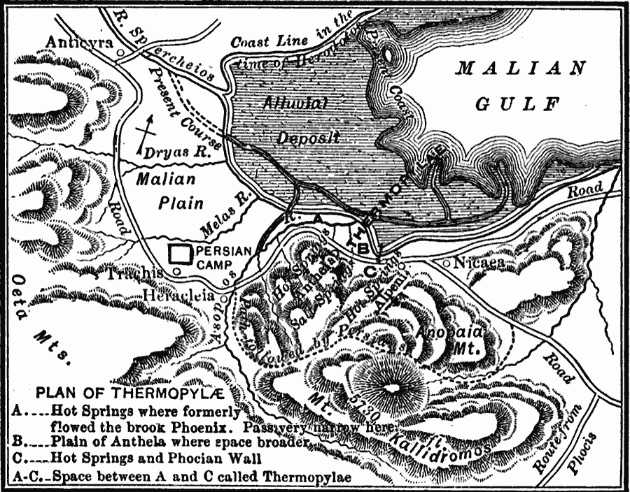
Description: A map of Thermopylae showing the site of the Battle of Thermopylae during the war between Greece and the Persians. This interesting map shows the present–day coastline and river course, and at the time of Herodotus (Greek historian). What is now alluvial deposit and dry land, was, at the time of the battle, water. Map notations show the hot springs where the River Phoenix flowed, and the pass narrowed (A), the Plain of Anthela where the pass broadens (B), the hot springs and Phocian Wall (C), and the space between A and C called Thermopylae (thermo for the hot springs, pylae or pylai meaning gate, as in gate in the Phocian Wall). The map shows the site of the camp of Xerxes I, and the secret mountain pass disclosed by Ephialtes that allowed the Persians to flank the Spartans.
Place Names: Greece, Nicea, �Trachis, �Anticyr
ISO Topic Categories: intelligenceMilitary,
inlandWaters,
location,
oceans,
transportation
Keywords: Plan of Thermopylae, physical, �transportation, �historical, kAncientGreece, kBattle, physical features, roads, other military, intelligenceMilitary,
inlandWaters,
location,
oceans,
transportation, Unknown, 480 BC
Source: George Willis Botsford, Ph. D., A History of Greece (London, : The Macmillan Company, 1912) 128
Map Credit: Courtesy the private collection of Roy Winkelman |
|