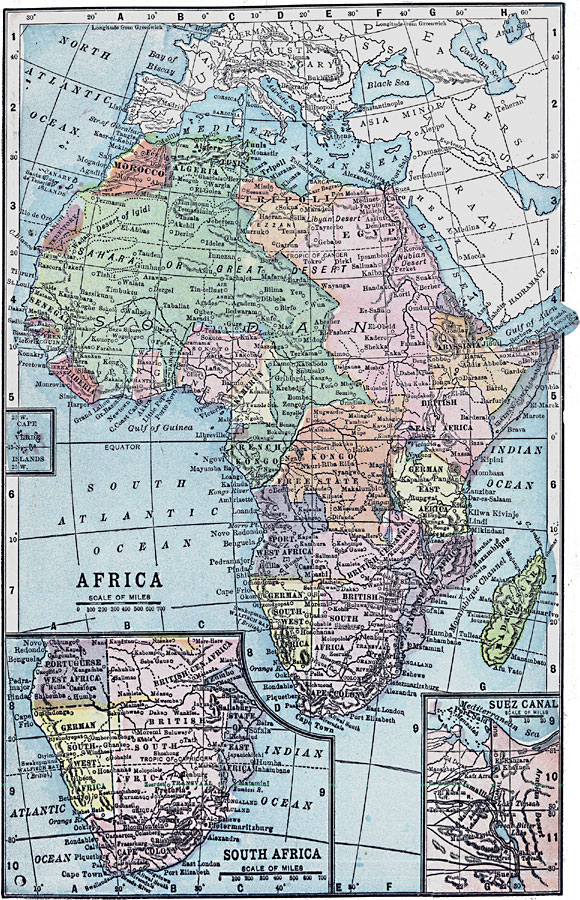
Description: A political map of Africa, as it was in 1903, showing European land claims after the Berlin Conference in 1885. The lack of natural boundaries, that is, boundaries along rivers, mountains, or native lands, shows the European system of arbitrary boundaries established along cadastral lines. Major cities and trade routes are shown. Inset maps show details of the Cape Verde Islands, South Africa, and the Suez Canal.
Place Names: A Complete Map of Africa, Congo, �Egypt, �Madagascar, �South Africa, �Algeria, �Morocco, Spanish Territory, Tripoli, Italian Somaliland, British East Africa, Kongo Freestate, French Kongo, Upper Guinea, German East Africa, State of East Africa, Portuguese West Africa, British Central Africa, German Southwest Africa, British South Africa, Rhodesia, Abyssinia, Eritrea
ISO Topic Categories: boundaries,
inlandWaters,
location,
oceans
Keywords: Colonial Africa, physical, �political, kBerlinConference, kNaturalCadastralBoundaries, kSuezCanal, physical features, country borders, boundaries,
inlandWaters,
location,
oceans, Unknown, 1903
Source: W. R. Hearst, The American Almanac, Yearbook Cycopedia and Atlas 2nd ed (Chicago, IL: Hearst's Chicago American, 1903) 249
Map Credit: Courtesy the private collection of Roy Winkelman |
|