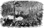
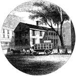
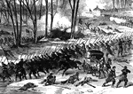
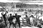
Battle of Carrick's Ford
"Battle of Carrick's Ford, between the troops of General McClellan's command, under General Morris,…
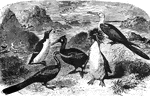
Grallatores
A group of Grallatores, an order with characteristically long legs, well suited for wading in shallow…
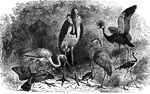
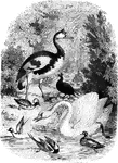
Natatores
A group of birds of the order natatores, whose webbed feet are well adapted for propelling them on and…
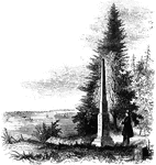
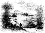
Group of Water Fowl
A group of water-fowl at a bank, with a fountain and pond visible in the background.
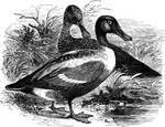
Shoveler
Also called the broad-bill and spoon-bill, the shoveler is commonly found on lakes and rivers, where…
Niagra Bridge
Part of Niagra Suspension Bridge. This view, looking up from the river, comprises about one half the…
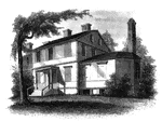
Mrs. Mathews' house
Mrs. Mathews' house. This sketch was made from the left bank of the Rahway, at the site of the old bridge.…
Liberty Hall
Liberty Hall. Some time after the death of Governor Livingston this property was purchased by Lord Blingbroke,…
Wintermoot's Fort
Site of Wintermoot's Fort. This view is from the ancient bed of the Susquehanna, looking west. The building,…
Monocasy Island
The Susquehanna at Monocasy Island. This view is from the left of eastern bank of the Susquehanna, opposite…
Queen Esther's Rock
Queen Esther's Rock. This view is near the ancient river bank, looking westward. The rock is a sort…
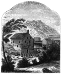
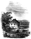
Van Schaick's Mill
Van Schaick's Mill. This view is taken from the left bank of the Walloomscoick, a little below the bridge.…
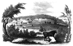
Bennington Battle-ground
The Bennington battle-ground. This view is from the hill on the southwest bank of the Walloomscoick,…
Agnew and Erskine
Head-quarters of Agnew and Erskine. This house is on the south bank of Still River, at the north end…
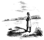
Williams landing-place
"Landing-place of Roger Williams. This view is on the left bank of the Seekonk, looking south. The point…
Providence Tavern
"Old Tavern in Providence. This view is from the market, looking north. The building stands on the east…
Gaspee Point
"Gaspee Point. This view is from the bank of the cove just below the Point, looking northeast, showing…
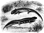
Salamanders
"The Land Salamanders, unlike the Tritons, are ovo-viparous, though the young at first inhabit the water…
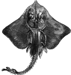
Bordered Ray
"Is two to three feet long, including the tail. The flesh is tolerably food, common on European coasts"…
Red Gurnard
"Twelve to sixteen inches long; it feeds on curstaceous animals; spawns in May or June; it is esteemed…
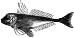
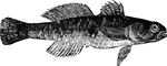
Bergylt
"Is twelve to twenty-four inches long; found in the northern seas, south to the coast of Massachusetts;…
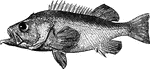
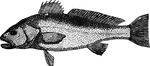
Dusky Serranus
"Common in the Mediterranean, and occaisionally found on the shores of Northern Europe, it weighs from…
Striped Red Mullet
"Weighs from two to six pounds; at some seasons it is abundant, and again it is scarce. It appears in…
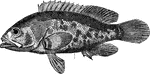
Black Goby
"It is five to six inches long, and found on the rocky coasts of Europe. It is not esteemed for food."…
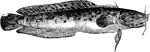
Three-Bearded Rockling
"It is twelve to fifteen inches long, frequents rocky ground, feeds on aquatic insects, takes bait,…
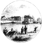
Trenton
"Trenton Bridge and vicinity. This view is from the north side of the Assanpink, a few rods above the…
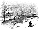
Worth's Mills
"Bridge at Worth's Mill's. This substantial stone bridge, over Stony Brook, is upon the site of the…
Red Bank Monument
"Monument at Red Bank. This view includes the monument, a portion of the Delaware, and the mouth of…
Walnut Street Prison
"The Walnut Street Prison. This edifice was erected in 1774, and taken down in 1836. The beautiful new…
Jefferis' Ford
"View at Jefferis' Ford. This view is from the easterly bank of the Brandywine. The ford was at the…
Chad's Ford
"View at Chad's Ford. This view is from the east bank of the Brandywine, looking southwest. The ford…
Graining
"Is found in the lakes and rivers of some parts of Europe; in its habits and food it resembles the trout,…
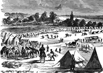
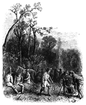
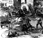
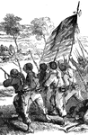
Camp Zagonyi
"Camp Zagonyi, encampment of Fremont's army on the prairie, near Wheatland, Mo., October 14th, 1861.…
Camp Zagonyi
"Camp Zagonyi, encampment of Fremont's army on the prairie, near Wheatland, Mo., October 14th, 1861.…
Camp Zagonyi
"Camp Zagonyi, encampment of Fremont's army on the prairie, near Wheatland, Mo., October 14th, 1861.…
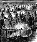
Battle of Stone River
"Battle of Stone River, Tenn. The decisive charge of General Negley's division across the river- the…
Battle of Stone River
"Battle of Stone River, Tenn. The decisive charge of General Negley's division across the river- the…
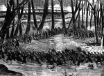
Battle of Stone River
"Battle of Stone River, Tenn. The decisive charge of General Negley's division across the river- the…
Bleak
"The Bleak or Blick, L. alburnus, is a well-known, small species, inhabiting many of the rivers…
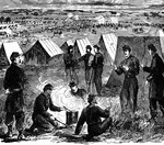
Battle of Antietam
"Battle of Antietam, Burnside's Division, left wing- brilliant and decisive bayonet charge of Hawkins's…
Battle of Antietam
"Battle of Antietam, Burnside's Division, left wing- brilliant and decisive bayonet charge of Hawkins's…
Redoubt
"View from the site of the Redoubt. This view is from the mounds looking northwest, up the York River.…
Tuckesege Ford
"View at Tuckesege Ford. This view is from the western bank of the Catawba, looking down the stream."—Lossing,…
Cherokee Ford
"View at the Cherokee Ford. This view is from the east bank of the river. Toward the extreme right is…
Hobkirk's Hill
"View at the Spring; Hobkirk's Hill. It is at the hed of a ravine, scooped out of the northeastern slope…
!["View from the site of Fort Cornwallis. Fort Cornwallis occupied the ground in the rear of the Episcopal church, now a grave-yard. This view is from within the inclosure, looking northeast, and includes a portion of Schultz's bridge, the Savannah River, and Hamburg upon the opposite bank. In the foreground is seen portions of the church-yard wall, and upon the brink of the river below are [African Americans] employed in placing bales of cotton upon the wharves for transportation to the sea-coast. The wharves are two stories in height, one to be used at low water, the other when the river is 'up.' There were remains of the ditch and embankments of the fort within the grave-yard when I was there; and the trench leading to the water-gate, where the 'Pride-of-India tree is seen, was very visible."—Lossing, 1851](https://etc.usf.edu/clipart/14100/14143/ft-cornwalli_14143_mth.gif)
Fort Cornwallis
"View from the site of Fort Cornwallis. Fort Cornwallis occupied the ground in the rear of the Episcopal…
Frederica
"Ruins of Oglethorpe's Barracks at Frederica. This is from a sketch made by W. W. Hazzard, Esq., in…
Turtle Bay
"View at Turtle Bay. Turtle Bay is a small rock-bound cove of the East River, at the foot of Forty-seventh…
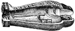
mummy
"Mummy. Another striking religious custom was the embalming of the dead. It was thought that the soul…
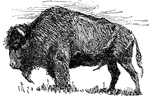
Buffalo
"The Buffalo. As the game upon which they depended moved about the country, so the Indians roved in…
Clio borealis
"The species of the genus Clio, belonging to this order, exist in prodigious numbers in the…
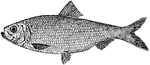
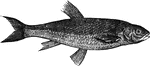
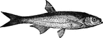
Alewife
"A North American fish, Clupea Vernalis, from 8 to 10 inches long, resembling a small shad, but much…
!["Like that animal [the mole] it is constantly engaged in burrowing in the earth; and to enable it to do this with facility iits anterior limbs are converted into a pair of flat, fossorial organs, which are turned outward in exactly the same manner as the hand of the mole. In its pasage through the earth it does great injury to the roots of plants, but it said to live quite as much upon animal as vegetable food." — Goodrich, 1859](https://etc.usf.edu/clipart/14900/14935/molecricket_14935_mth.gif)
Mole Cricket
"Like that animal [the mole] it is constantly engaged in burrowing in the earth; and to enable it to…
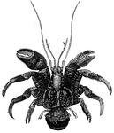
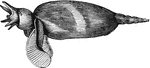
Purse-crab
"The Purse Crab, Birgus Latro is a very curious species found in Amboyna and some of the adjacent…
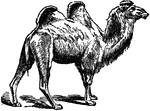
Camel
"Camel is a genus of ruminant quadrupeds, characterized by the absence of horns; a fissure in the upper…
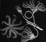
Encrindae
"Theses animals were all supported upon a long stalk, at the extremity of which they floated in the…
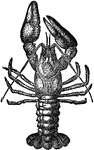
Crawfish
"Crawfish, or Crayfish is a name of various crustaceous animals, the common crawfish being the river…
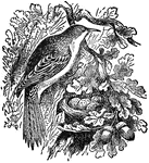
Common Creeper
"Creepers are a family of birds which strongly resemble the woodpeckers in their habit of creeping on…