Clipart tagged: ‘basin plan’
Irrigation by Checks
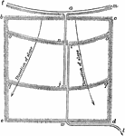
"A modification of the basin plan, as applied to ground with considerable slope and consisting of hillside…
Irrigation by Furrows
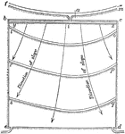
One way to spread water over a hillside field, "f m is the main ditch and the slope of the hill as shown…