Maps Site map
  Maps > Asia > Syria
Site Map  

  Record   1   to   3  of   3

Historic and contemporary maps of Syria for use in the K-12 classroom.

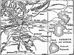
Environs of Damascus, 1919
A map from 1919 of the region around Damascus, Syria, showing the mountains and terrain features of the area, major roads and railways, rivers, canals, lakes, and neighboring cities and villages. The map shows the lakes (bahret) of esh–Silarkiy...

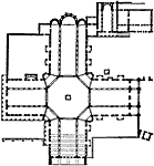
Plan of Church of Kalb-Lauzeh, AD 380–609
This is a plan of the church of Kalb–Lauzeh (Qalb Lozeh), Syria. This is an example of Early Christian architecture....

Plan of Church of Kalat-Seman, AD 459 to 599
A plan of the church of Kalat–Seman in the northern Syrian city of Aleppo. The church is also known as St. Simon Stylites, Samaan, or San Simeon, consecrated in AD 476, and is considered to be one of the oldest remaining churches in the world....


  Maps > Asia > Syria
Site Map  

Maps ETC is a part of the Educational Technology Clearinghouse
Produced by the Florida Center for Instructional Technology © 2009
College of Education, University of South Florida