|
|
|
| Maps > Europe > Hungary |
A collection of historic and contemporary political and physical maps of Hungary, including early history and empire, boundary changes, and break up after WWI.
|
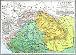
Hungary at the End of the Sixteenth Century,
1490–1606 |
|
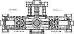
Plan of the Parliament House, Budapest,
1885–1902 |
|
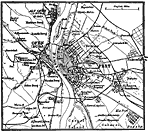
Budapest, Hungary,
1914 |
| Maps > Europe > Hungary |
Maps ETC is a part of the Educational Technology Clearinghouse
Produced by the Florida Center for Instructional Technology © 2009
College of Education, University of South Florida