Maps Site map
  Maps > Oceania > Papua New Guinea
Site Map  

  Record   1   to   2  of   2

A collection of historic and contemporary political and physical maps of Papua New Guinea, including colonial period maps, for use in the K-12 classroom.
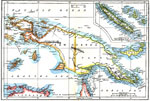
New Guinea and New Caledonia, 1903
A map of New Guinea or Papua from 1903 showing various islands, mountain ranges, rivers, and other bodies of water. An inset map details New Caledonia and the Loyalty Islands. "New Guinea, the largest island in the world (excluding Australia), l...

British New Guinea, 1920
A map from 1920 showing the British territorial claim in Papua New Guinea at the time. The map shows the boundaries with Dutch New Guinea and the German territory of Kaiser Wilhelm's Land, major cities, towns, and ports, rivers, and coastal features....


  Maps > Oceania > Papua New Guinea
Site Map  

Maps ETC is a part of the Educational Technology Clearinghouse
Produced by the Florida Center for Instructional Technology © 2009
College of Education, University of South Florida