Maps Site map
  Maps > United States > Forestry
Site Map  

  Record   11   to   14  of   14

A collection of Forestry and Timber maps in the United States for use in the K-12 classroom.
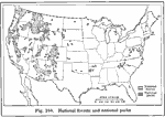
National Forests and Parks, 1916
A map from 1916 of the United States showing the National Forests and National Parks of the country. ...

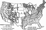
Forest Planting Regions in the United States, 1919
A map from 19169 of the United States showing the forest planting regions of the United States. The un–shaded areas are treeless except along the streams (riparian)....

Increasing Distance from Lumber Producers to Lumber Consumers, 1920
A map of the United States from the U. S. Department of Agriculture (1922) showing the increasing distance lumber had to travel to go from the production areas in the south and west to the consumption areas in the east. The map shows areas of lumper ...

Organized Protection Against Forest Fires, 1922
A map of the United States from the U. S. Department of Agriculture (1922) showing the funds distribution at the time dedicated to forest fire prevention compared to the funds needed to adequately protect forest land. The map shows areas where no fun...

First Previous


  Maps > United States > Forestry
Site Map  

Maps ETC is a part of the Educational Technology Clearinghouse
Produced by the Florida Center for Instructional Technology © 2009
College of Education, University of South Florida