Clipart tagged: ‘valley’
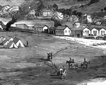
Bellaire
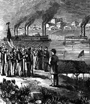
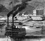
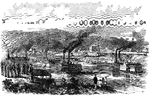
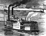
"Bellaire, O.- Steamboats conveying troops and munitions of war for the Federal forces on the Great…
Bellaire
"Bellaire, O.- Steamboats conveying troops and munitions of war for the Federal forces on the Great…
Bellaire, Ohio
"Bellaire, O.- Steamboats conveying troops and munitions of war for the Federal forces on the Great…
Bellaire
"Bellaire, O.- Steamboats conveying troops and munitions of war for the Federal forces on the Great…
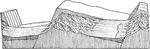
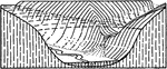
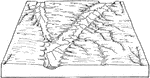
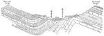
Block Faulting Results
Diagram showing mountains and valleys due to block faulting in the background, and the dissection of…
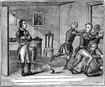
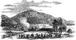
True Bravery
True Bravery, the American Army at Valley Forge in 1777. Caption below illustration: "After mentioning…

Limestone Cavern
"Section of a Limestone Cavern...A limestone hill, perforated by a cavern (b b) which communicates with…
Limestone Cavern
"Section of a Limestone Cavern with fallen-in roof and concealed entrance." -Geikie, 1893
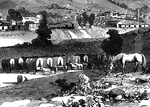
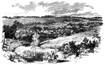
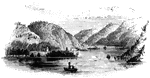
Valley of Chickahominy
"Valley of the Chickahominy, looking southeast from the vicinity of Mechanicsville, the scene of the…
Valley of Chickahominy
"Valley of the Chickahominy, looking southeast from the vicinity of Mechanicsville, the scene of the…
Valley of Chickahominy
"Valley of the Chickahominy, looking southeast from the vicinity of Mechanicsville, the scene of the…
Valley of Chickahominy
"Valley of the Chickahominy, looking southeast from the vicinity of Mechanicsville, the scene of the…
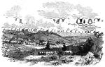
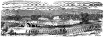
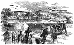
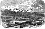
Village of Clarksburg
"Village of Clarksburg, Western Virginia, headquarters of General Rosecrans. Clarksburg, a post village,…
Village of Clarksburg
"Village of Clarksburg, Western Virginia, headquarters of General Rosecrans. Clarksburg, a post village,…
Village of Clarksburg
"Village of Clarksburg, Western Virginia, headquarters of General Rosecrans. Clarksburg, a post village,…
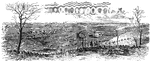
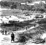
Confederate Position
"Confederate position near Centreville, Va., at the crossing of the Orange and Alexandria Railway over…
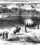
Battle of Cross Keys
"Battle of Cross Keys, Sunday June 8th, 1862- centre and front of the Federal army in the engagement.…
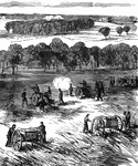
Battle at Dam No. 4
"Battle at Dam No. 4, Potomac River, between Butterfield's brigade and a large Confederate force. A…
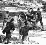
Battle at Dam No. 4
"Battle at Dam No. 4, Potomac River, between Butterfield's brigade and a large Confederate force. A…
Battle at Dam No. 4
"Battle at Dam No. 4, Potomac River, between Butterfield's brigade and a large Confederate force. A…
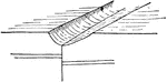
Fault Line Valley
A fault line valley. A fault line, is a planar fracture in rock in which the rock on one side of the…
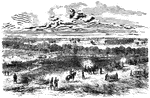
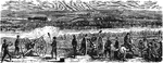
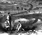
Cavalry of General Banks
"A reconnoitring detachment of General Banks's cavalry, Hyattstown, Md., in the distance. There are…
Glaciers
Diagram to illustrate the relationship of main and tributary glaciers. The surfaces of the two glaciers…
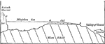
Marjelen Lake
Diagrammatic section of the Marjelen Lake, the Aletsch Glacier which holds it and the valley of the…
Lateral Moraine
In the valley glaciers, the rock fragments falling upon the ice from the valley sides, or sliding down…
Medial Moraine
Where two glacial streams unite, their adjoining lateral moraines become confluent and are continued…
Oatka and Dale Valleys
Diagram showing the junction of the Oatka and Dale Valleys near Warsaw. The Dale is a hanging valley…
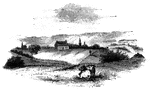
Old Parsonage and Church
Old Parsonage and Church. This view is from the high plain on the right of the block-house, looking…
Battle at Potomac
"Engagement between the Federal troops and the Confederates on the Virginia side of the Potomac, opposite…
Rock Layers Showing Types of Rock
"Cross section of Marsh Creek valley at McCammon, Idaho." -Lee, 1915
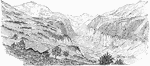
Roger's Rock
Roger's Rock. This sketch is from the lake, a little south of Cook's Point, seen just over the boat…
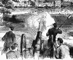
Crossing of Shenandoah River
"Colonel Pilson's Battery shelling the rear guard of the Confederate General Jackson's Army, at the…
Strasburg
"Reconnoissance of the Confederate poistion at Strasburg, VA., by a detachment of cavalry under General…
Strasburg Lookout
"View of the town of Strasburg, valley of the Shenandoah, occupied by the Federal forces under General…
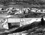
Bridge at Strasburg
"View of the town of Strasburg, valley of the Shenandoah, occupied by the Federal forces under General…
View of Strasburg
"View of the town of Strasburg, valley of the Shenandoah, occupied by the Federal forces under General…
Valley
An image of what a regular valley would look like if it were cut to make a plateau and lowlands.