The Miscellaneous Illustrations of New York ClipArt gallery includes 87 images related to the Empire State.

The Battle of Big Sandy Creek was fought in northwestern New York on May 29 – May 30, 1814, during the War of 1812.

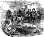
Place of Battle at Sandy Creek

The Battle of Big Sandy Creek was fought in northwestern New York on May 29 – May 30, 1814, during…
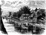
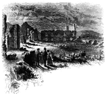
Schenectady is a city in Schenectady County, New York, United States. Pictured here is a bit of old Schenectady.

Schenectady

Schenectady is a city in Schenectady County, New York, United States. Pictured here is a bit of old…
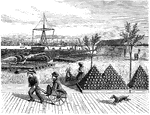
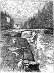
The mill of General Schuyler, an American Revolution war general.

General Schuyler's Mill

The mill of General Schuyler, an American Revolution war general.

Early Dutch Man of war used in New York during the late 1600s.

Dutch Man War Ship

Early Dutch Man of war used in New York during the late 1600s.

An illustration of the ordinance dock located in the Brooklyn Shipyard. To the bottom right of the illustration notice the stacks of cannons and at the top right, parts of ships laid out on the ground.

Shipyard Dock

An illustration of the ordinance dock located in the Brooklyn Shipyard. To the bottom right of the illustration…
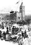
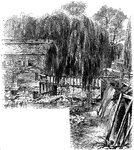
Hoisting the skating flag on the Belvedere in Central Park, New York.

Skating Flag

Hoisting the skating flag on the Belvedere in Central Park, New York.

"Bridge over Sleepy Hollow Creek. Ichabod, according to Irving, in the <em>Legend</em>, returning from a late evening tarry with Katrina Van Tassel, on his lean steed Gunpowder, was chased by a huge horseman, without a head, from the Andre tree to the bridge. 'He saw the walls of the church dimly gleaming under the trees beyond. He recollected the place where Brom Bones' ghostly competitor had disappeared. "If I can reach that bridge," thought Ichabod, "I am safe." Just then he heard the black steed panting and blowing close behind him; he even fancied that he felt his hot breath. Another compulsive kick in the ribs, and old Gunpowder sprang upon the bridge; he thundered over the resounding planks; he gained the opposite side; and now Ichabod cast a look behind, to see if his pursuer should vanish, according to rule, in a flash of fire and brimstone. Just then he saw the goblin rising in his stirrups, and in the very act of hurling his head at him. Ichabod endeavored to dodge the horrible missile, but too late; it encountered his cranium with a terrible crash; he was tumbled headlong into the dust, and Gunpowder, the black steed, and the goblin rider, passed like a whirlwind.' A shattered pumpkin was found on the road the next day, but Ichabod had gone to parts unknown. Brom Bones, his rival, soon afterward let the pretty Katrina to the altar. The good country people always maintained that Ichabod was spirited away by the <em>headless horseman</em>, who was the ghost of a Hessian soldier, whose body, deprived of its caput by a cannon-ball, ws sleeping in the church-yard near."&mdash;Lossing, 1851

Sleepy Hollow

"Bridge over Sleepy Hollow Creek. Ichabod, according to Irving, in the Legend, returning from…

The mill at Sleepy Hollow, New York.

The Old Mill at Sleepy Hollow

The mill at Sleepy Hollow, New York.

New York City Stamp (3 cent) from 1842. This stamp was acknowledged and ordered by the United States Government, but was issued by and at the expense of the Postmaster of New York City, New York.

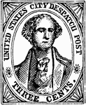
New York City Three Cent Stamp, 1842

New York City Stamp (3 cent) from 1842. This stamp was acknowledged and ordered by the United States…

Peter Struyvesant was the last Dutch governor of the New Netherlands colony.

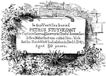
Peter Struyvesant in New Amsterdam

Peter Struyvesant was the last Dutch governor of the New Netherlands colony.

The tomb of Petrus Stuyvesant

Stuyvesant Tomb

The tomb of Petrus Stuyvesant

Illustrated is the free center of the Meadow, Central Park.

The Meadow

Illustrated is the free center of the Meadow, Central Park.

Ticonderoga at sunset.

Ticonderoga

Ticonderoga at sunset.

The crossing between Lakes George and Champlain had been used by natives for thousands of years. The town was located on the direct route, utilizing rivers and two long lakes, between New York City to the south and the French settlement of Montreal to the north. The town was the setting for historic battles and maneuvers during both the French and Indian War and the American Revolution. The site of Fort Ticonderoga marked the location of an important portage between Lake George and Lake Champlain.

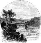
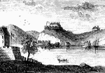
Ticonderoga and the Lake, from Mount Defiance

The crossing between Lakes George and Champlain had been used by natives for thousands of years. The…

Hard Times Token (unknown) US coin from 1834. Obverse has a left-facing sailing ship with the inscription - FOR THE CONSTITUTION HURRA! Reverse is inscribed with WHIGS OF N. YORK VICTORIOUS LES TROIS JOURS APRIL 8, 9, & 10, 1834 surrounded by the inscription - FLOURISH COMMERCE, FLOURISH INDUSTRY

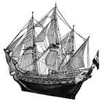
Brass Hard Times Token, 1834

Hard Times Token (unknown) US coin from 1834. Obverse has a left-facing sailing ship with the inscription…

Hard Times Token (unknown) US coin. Obverse has an image of the front of the Merchants Exchange surrounded by the inscription - MERCHANTS EXCHANGE WALL ST N YORK BUILT 1827 BURNT 1835. Reverse shows the center inscription - NOT ONE CENT FOR TRIBUTE surrounded by a wreath with 9 berries - 3 outside and 6 inside the wreath with a surrounding inscription - MILLIONS FOR DEFENCE.

Copper Hard Times Token, ND

Hard Times Token (unknown) US coin. Obverse has an image of the front of the Merchants Exchange surrounded…

Children in front of a toy shop in New York.

Toy Shop

Children in front of a toy shop in New York.

Settlers of the Colony of New York trading with Native Americans.

Trading with the Indians

Settlers of the Colony of New York trading with Native Americans.

"View at Turtle Bay. Turtle Bay is a small rock-bound cove of the East River, at the foot of Forty-seventh Street. The banks are high and precipitous, and afforded a safe retreat for small vessels. Here the government had made a magazine of military stores, and these the Sons of Liberty determined to seize. Under the direction of Lamb, Sears, Willett, and McDougal, a party procured a sloop at Greenwich, came stealthily through the dangerous vortex of Hell Gate at twilight, and at midnight surprised and captured the guard, and secured the stores. The old store-house in which they were deposited is yet standing upon a wharf on the southern side of the little bay. The above view is from the bank at the foot of Forty-sixth Street. Beyond the rocky point on the north side of the bay is seen the lower end of Blackwell's Island, with the shore of Long Island in the distance. On the left of the old store-house, is seen the bridge across the mouth of Newtown Creek, a locality which will be mentioned presently in connection with a notice of the landing of troops under Sir Henry Clinton."—Lossing, 1851

Turtle Bay

"View at Turtle Bay. Turtle Bay is a small rock-bound cove of the East River, at the foot of Forty-seventh…

Lake George, also known as <em>Queen of American Lakes</em>, is a long narrow lake at the southeast base of the Adirondack Mountains, northern New York. The lake extends about 32.2 miles on a north-south axis and varies from 1 to 3 miles in width.

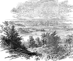
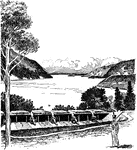
View of Lake George, N.Y.

Lake George, also known as Queen of American Lakes, is a long narrow lake at the southeast…

In some churches, pews were installed at the expense of the congregants, and were their personal property; there was no general public seating in the church itself. In these churches, pew deeds recorded title to the pews, and were used to convey them. Pews were originally purchased from the church by their owners under this system, and the purchase price of the pews went to the costs of building the church. Pictured here is George Washington's family pew at St. Paul's Episcopal Church in New York.

Washington's Pew at St. Paul's, New York

In some churches, pews were installed at the expense of the congregants, and were their personal property;…

"View at Fort Washington. This is a view from the site of the interior works at Fort Washington from the foot of the flag-staff, loking southwest. In the foreground are seen the remains of the embankments. The tall mast seen near the river below is the support for telegraph wires which cross the Hudson there, from the rocky point of Jefrrey's Hook. In the distance across the river are the Palisades, and the mast upon their summit denotes the site of the redoubt north of Fort Lee. This little sketch exhibits the relative position of Forts Washington and Lee."&mdash;Lossing, 1851

Fort Washington

"View at Fort Washington. This is a view from the site of the interior works at Fort Washington from…
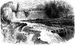
An illustration of Horse Shoe and Birmingham Falls.

Waterfall

An illustration of Horse Shoe and Birmingham Falls.

Trenton Falls, a geologist's playground, has been inspiring generations of scientists. Referred to as Kuyahoora by the natives, the leaping waters of the Deyoghtararon, was held in great spiritual regard by native peoples for centuries prior to the arrival of settlers. Trenton Falls is located in West Canada Creek Valley in north central New York State. This tributary of the Mohawk River drains much of the southwestern Adirondack Mountains. Limestone and shale dominate the rock formation at Trenton Falls.

Trenton High Falls

Trenton Falls, a geologist's playground, has been inspiring generations of scientists. Referred to as…
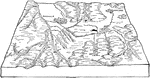
Diagram illustrating the relation of the Dansville to the Wayland Valleys. The floor of the Wayland Valley at Wayland has an elevation of 1372 feet. Its continuation on the extreme left hand of the diagram is 1300 feet. The elevation of the Dansville Valley at Dansville is 700 feet. Both valleys are partially filled by drift. The streams which dissect the Wayland Valley have cut narrow gorges in the rock bottom.

Wayland Valleys

Diagram illustrating the relation of the Dansville to the Wayland Valleys. The floor of the Wayland…

West Point under the control of the British, secured by Benedict Arnold.

West Point

West Point under the control of the British, secured by Benedict Arnold.

"West Point in 1780. This view is from a print published in the <em>New York Magazine</em> for 1790. It was taken from Constitution Island. On the left is seen a portion of old Fort Constitution. The great chain, four hundred and fifty yards in length, and covered by a strong battery, is seen stretched across the river, immediately below Fort Clinton, the structure on the high point. In the distance, on the left, two mountain summits are seen, crowned with fortifications. These were the North and Middle Redoubts. Upon the range of the Sugar Loaf Mountain, higher than these, and hidden, in the view, by Fort Clinton, was another redoubt, called the South Battery."—Lossing, 1851

West Point

"West Point in 1780. This view is from a print published in the New York Magazine for 1790.…