|
|
|
| Maps > United States > Georgia |
A collection of historic and contemporary political and physical maps of Georgia, including campaign and battle plans, for use in the K-12 classroom.
|
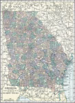
Georgia,
1920 |
|
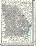
Georgia,
1920 |
|
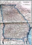
Georgia,
1922 |
|
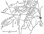
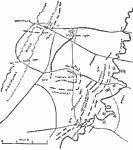
Operations about Marietta,
June 14–28, 1864 |
|
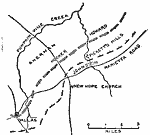
Pickett's Mills and New Hope Church,
May 1864 |
|
Chickamauga,
September 1863 |
| First | Previous |
| Maps > United States > Georgia |
Maps ETC is a part of the Educational Technology Clearinghouse
Produced by the Florida Center for Instructional Technology © 2009
College of Education, University of South Florida