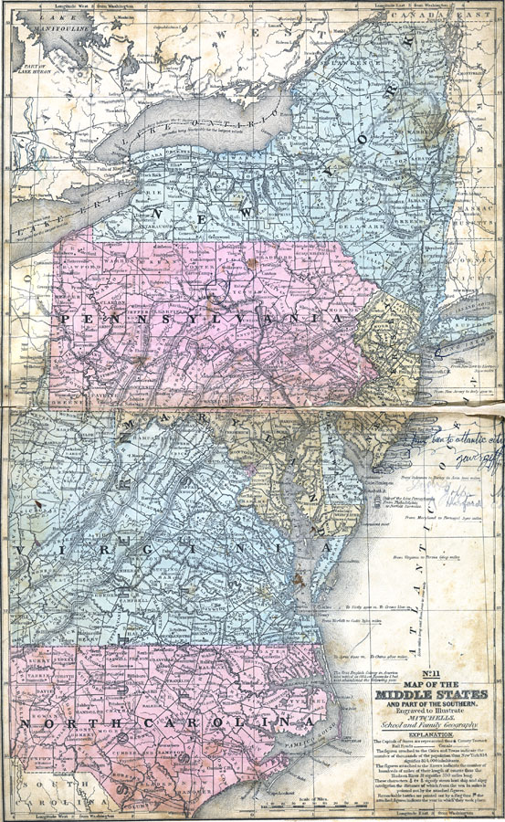
Description: The Middle States and part of the Southern states. The capitals of States are represented with a ring of dots around the city dot. County towns are represented by a circle around the dot. Rail roads are double lines with slashes across them, canals are double lines. The figures attached to the Cities and Towns indicate the number of thousands of the population thus New York 814 signifies 814,000 inhabitants. The figures attached to the Rivers indicate the number of hundreds of miles of their length of course thus the Hudson River 3 and one half signifies 350 miles long. The anchor shape figures signify steam boat and sloop navigation the distance of which from the sea in miles is pointed out by the attached figures. Remarkable battles are pointed out by a flag. the attached figures indicate the year in which they took place.—Mitchell's School Atlas, 1863
Place Names: Middle Atlantic States, New York, �Washington D.C., �Raleigh, Dover, Trenton, Harris, Philadelphia, Albany, Richmond, �East Coast, �North Carolina, �Delaware, �Virginia, �New Jersey, �Pennsylvania,
ISO Topic Categories: boundaries,
elevation,
inlandWaters,
location,
oceans,
transportation
Keywords: The Middle States, physical, �political, �transportation, �historical, physical features, country borders,
major political subdivisions,
county borders, water routes,
railroads, historical event,
American Revolution, boundaries,
elevation,
inlandWaters,
location,
oceans,
transportation, Unknown, 1858
Source: , Mitchell's School Atlas (Philadelphia, PA : E. H. Butler & Co., 1863)
Map Credit: Courtesy the private collection of Roy Winkelman |
|