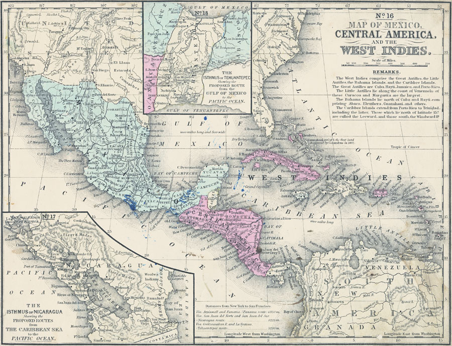
Description: A map from 1852 of Mexico, Central America, and the West Indies. The map shows territorial boundaries at the time, including the Mexican States, capitals and major cities and ports, railroads, rivers, lakes, mountain systems, and terrain coastal features of the region. The Capitals of Countries are represented with a dot with a ring of dots around it. The figures attached to Cities and Towns indicate the number of thousands of the population, thus City of Mexico 200 signifies 200,000 inhabitants. The figures attached to the islands indicate the number of miles of their length. The map indicates the ship route distances between New York and San Francisco via the three proposed cross–isthmus routes at Panama, Nicaragua, and Tehuantepec, Mexico, with inset maps detailing the Nicaragua and Tehuantepec routes. "The West Indies comprise the Great Antilles, the Little Antilles, the Bahama Islands, and the Caribbee Islands. The Great Antilles are Cuba, Hayti, Jamaica, and Porto Rico. The Little Antilles lie along the coast of Venezuela, of these Curacoa and Margarita are the largest. The Bahama Islands lie north of Cuba and Hayti comprising Abaco, Eleuthera, Guanahani, and others. The Caribbee Islands extend from Porto Rico to Trinidad, including the latter. Those which lie north of latitude 15 degrees are called the Leeward, and those south, the Windward islands." —Mitchell's School Atlas, 1863.
Place Names: A Regional Map of North America, Bahamas, �Cuba, �Mexico, �West Indies, Venezuela, New Granada, Central America, Mexico City, Leon, San Salvador, New Guatamala, San Jose, Yucatan Peninsula, Bay of Guatimala, Comayagua, Balize, Campeche, Havana, �Caribbe
ISO Topic Categories: boundaries,
inlandWaters,
location,
transportation,
oceans
Keywords: Mexico, Central America and the West Indies, physical, �political, �transportation, kCaribbean, kCentralAmerica, physical features, major political subdivisions,
country borders, railroads,
water routes, boundaries,
inlandWaters,
location,
transportation,
oceans, Unknown, 1852
Source: , Mitchell's School Atlas (Philadelphia, PA : E. H. Butler & Co., 1863)
Map Credit: Courtesy the private collection of Roy Winkelman |
|