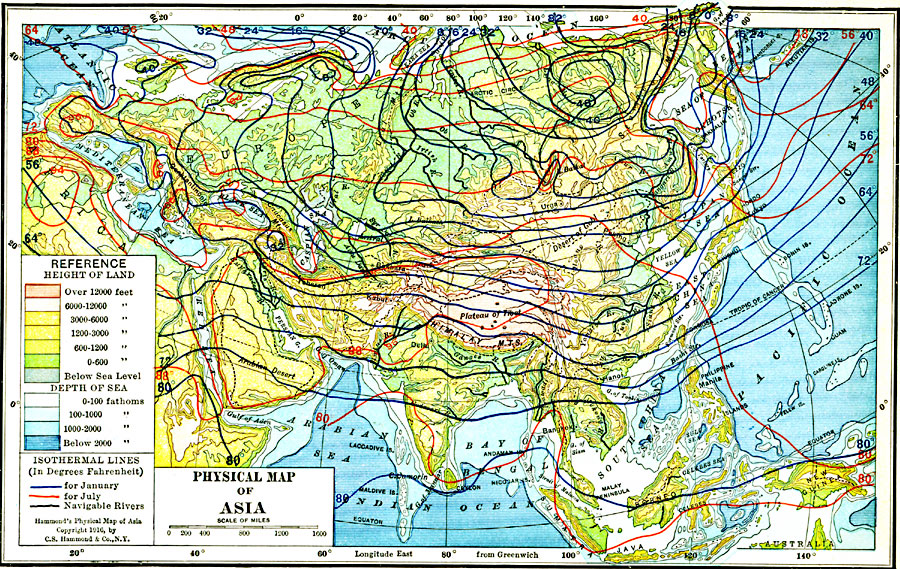
Description: A map from 1916 of Asia, showing physical features, general elevations, and mean isotherms for January and July. This map uses color-contours to show land elevations ranging from below sea level around the Caspian Sea to over 12000 feet, and water depths given in fathoms from sea level to below 2000 fathoms. The light blue tints indicate the submerged continental plateau of the region. Isotherms of mean January temperatures given in degrees Fahrenheit are shown with blue lines, with isotherms for July shown with red lines. Political boundaries at the time are shown with dashed black lines. This map shows mountain systems, plateaus, plains, deserts, major river systems with navigable rivers shown with heavy black lines, lakes, coastal features, and islands.
Place Names: A Complete Map of Asia,
ISO Topic Categories: boundaries,
inlandWaters,
location,
oceans,
climatologyMeteorologyAtmosphere,
transportation
Keywords: Physical Asia with Isotherms, physical, �political, �meteorological, �transportation, �hydrological, kClimate, physical features,
topographical, country borders, water routes, temperature, water depths, boundaries,
inlandWaters,
location,
oceans,
climatologyMeteorologyAtmosphere,
transportation, Polyconic, 1916
Source: , Hammond's Business Atlas of Economic Geography (New York, NY: C.S. Hammond and Co., 1919) 17
Map Credit: Courtesy the private collection of Roy Winkelman |
|