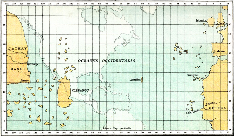
Description: This map is a representation of the map and letter sent to the court of Lisbon by Palolo dal Ozzo Toscanelli in 1474. This was thought to be the westward route to the Spice Islands and was carried with Christopher Columbus during his first voyage to the new world. Toscanelli had miscalculated the size of the earth, which resulted in Columbus never realizing he had found a new continent. The outline of where North America actually lies is shown on the map in light blue tint.
Place Names: Regional Atlantic Ocean, Toscanelli, �Oceanus Occidentalis, �Cathay, �Mangi, �Guinea, �Cippangu, �Antilli
ISO Topic Categories: physical, kWorldAmericas, kWorldAtlantic
Keywords: Atlantic Ocean, Toscanelli, physical, physical features, physical, kWorldAmericas, kWorldAtlantic, Unknown, 1474
Source: Ernest Rhys, Ed., A Literary and Historical Atlas of North & South America (New York, NY: E.P. Dutton & CO., 1911) 1
Map Credit: Courtesy the private collection of Roy Winkelman |
|