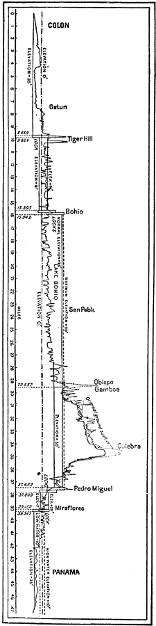
Description: A vertical cross–section chart from 1906 of the Panama Canal showing elevation and the location of locks. "The canal extends from a six–fathom line in Colon harbor on the Atlantic to a six–fathom line off Panama on the Pacific. The first 16 miles from the Atlantic to Bohio is a tide level canal. At Bohio a dam will be thrown across the Chagres River. This dam will be of sufficient height to form a lake in the valley of the Chagres, whose surface will be 90 feet above sea level and whose area will be sufficient to provide for all overflow in the rainy season. At this point there will be a set of locks whose combined lift will be 90 feet. From these locks the canal traverses Lake Bohio for 14 miles. There are two sets of locks at the Pacific terminus of the summit level, 8 miles from the Pacific terminus." —Vaughn,1906.
Place Names: Panama Canal Zone, Panama Canal, ��Colon, �Panam
ISO Topic Categories: elevation,
inlandWaters,
transportation
Keywords: Panama Canal, transportation, �physical, �Canal, topographical, water routes, elevation,
inlandWaters,
transportation, Unknown, 1906
Source: L. Brent Vaughn, Hill's Practical Reference Library of General Knowledge Volume III (New York, NY: Dixon, Hanson & Company, 1906)
Map Credit: Courtesy the private collection of Roy Winkelman |
|