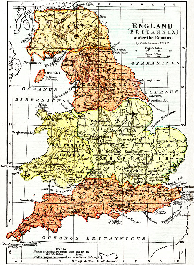
Description: A map of England (Britannia) under the Roman Empire, from the time of the first invasion by Julius Caesar (55 BC) to the Roman withdrawal in AD 410. The Roman Period of control of Britannia is generally considered AD 43 to 410. On this map, Roman place names are in Latin, with modern names in parentheses. Roman territories are in bold caps, and the territories of the British Tribes are in bold italics. The map shows Roman roads and defensive walls (Antonine and Hadrian's), major cities of the time, major river ways, topography, and coastal waters. The scale is shown in both English and Roman Miles. The Roman territories shown are Britannia Prima, Britannia Secunda, Flavia Caesariensis, Maxima Caesariensis, and Valentia.
Place Names: United Kingdom, London, �Manchester, �Tamesis &Aelig;st., �River Thames, �Londinium, �Isle of Wight, �Vectis Isle, �Bath, �Aquæ Solis, �York, �Eboracuni, ���
ISO Topic Categories: boundaries,
inlandWaters,
oceans
Keywords: England under the Romans, physical, �political, �transportation, �historical, physical features,
topographical, country borders,
major political subdivisions, roads,
water routes, boundaries,
inlandWaters,
oceans, Unknown, 55 BC to AD 410
Source: Keith Johnston, The Half-Crown Atlas of British History (Edinburgh, Scotland: W. & A. K. Johnston, 1871) 1
Map Credit: Courtesy the private collection of Roy Winkelman |
|