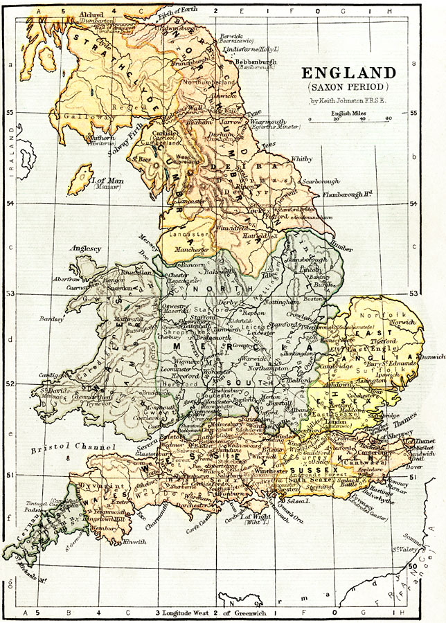
Description: A map of England, Wales, and southern Scotland during the Saxon Period from around AD 450 to the beginning of the Norman Conquest in 1066. This map shows major cities of the time, major river ways, topography, and is color–coded to show the territories of the period, including Strathclyde, Northumbria, Cumbria, Wales (Cambria), Mercia, East Anglia, Essex, Kent, Sussex, Wessex, and West Wales. Several remnants from the Roman period are shown, such as Watling Street, Antonine Wall (Grahams Dyke), and Hadrian's Wall (Picts Wall), and many place names, particularly in the northeast, are shown with periodic variation names, such as Berwick (Beornicawic), Bebbanburgh (Bamborough), and Kent (Cantwara). Several important battle sites are shown, including Ockley (851), Senlac Hill (1066), Ashdown (871), Idle (616), Brunanburh (937), and others.
Place Names: United Kingdom, London, �Manchester, �River Thames, �Isle of Man, �Manaw, �Cambridge, �Whales, �West Whales, �Avon River, �Mersey River, �Winchester, �Nottingham,
ISO Topic Categories: boundaries,
elevation,
inlandWaters,
transportation
Keywords: England during the Saxon Period, physical, �political, �transportation, �historical, physical features,
topographical, country borders,
major political subdivisions, water routes, boundaries,
elevation,
inlandWaters,
transportation, Unknown, AD 450–1066
Source: Keith Johnston, The Half-Crown Atlas of British History (Edinburgh, Scotland: W. & A. K. Johnston, 1871) 4
Map Credit: Courtesy the private collection of Roy Winkelman |
|