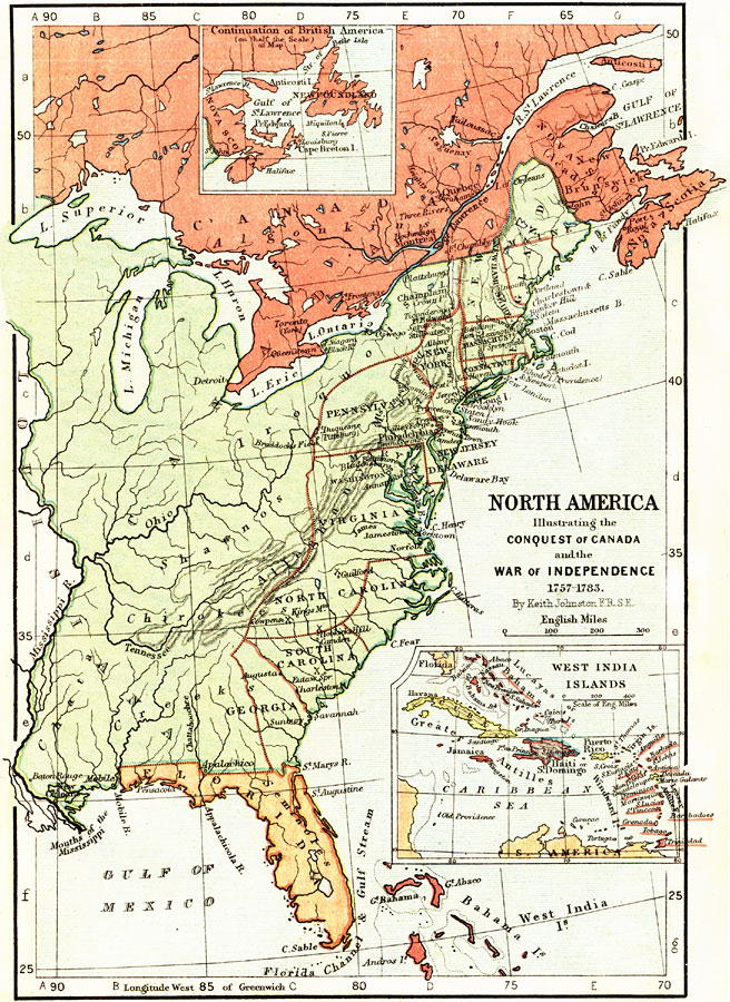
Description: A map of eastern North America illustrating the Conquest of Canada and the War of Independence (1757–1783). The map shows major cities of the time, major river ways, topography and political boundaries. The map is color–coded to show the Canadian territories (British America), the territories claimed by the United States to the Mississippi River, and Florida as a Spanish possession. Significant battle sites and forts of the period are indicated, as well as the state boundaries of the American colonies. Map scale in English miles. There is an insert of the continuation of the British America at the top (Nova Scotia and Newfoundland), and at the bottom left there is a detailed insert of the West India Islands including Cuba to the Lesser Antilles and the Bahamas.
Place Names: A Regional Map of North America, Bahamas, �Canada, �United States, �North America east of the Mississippi River, �Lake Superior, �lake Michigan, �Lake Huron, �Lake Erie, �Lake Ontario, �St. Lawrence River, �Nova Scotia, �Algonkin, �Iroquoi, �Shawnos, �Mississippi River, �Ohio River, �
ISO Topic Categories: boundaries,
elevation,
inlandWaters,
oceans,
transportation
Keywords: North America illustrating the Conquest of Canada and the War of Independence, physical, �political, �transportation, �historical, physical features,
topographical, country borders,
major political subdivisions, water routes, American Revolution, boundaries,
elevation,
inlandWaters,
oceans,
transportation, Unknown, 1757–1783
Source: Keith Johnston, The Half-Crown Atlas of British History (Edinburgh, Scotland: W. & A. K. Johnston, 1871) 26
Map Credit: Courtesy the private collection of Roy Winkelman |
|