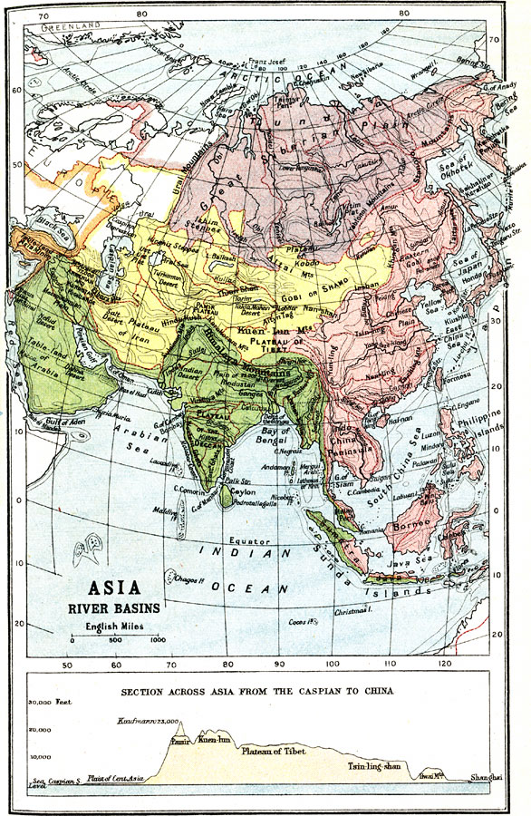
Description: A map from 1912 showing the various drainage basins across the Asian region. This map is color-coded to show watersheds draining to the Pacific Ocean in pink, to the Indian Ocean in green, to the Arctic Ocean in purple and inland basins that do not drain to the sea in yellow. The divide separating individual watersheds are shown by red lines. Landform features and contour lines that effect drainage are shown, including the Great Siberian Plain, Table-Land of Arabia, Plateau of Iran, Plateau of Deccan, Himalayan Mountains, Plateau of Tibet, Gobi Basin, and Chinese Plain. A chart at the bottom of the map shows an east–west cross-sectional profile from the Caspian Sea to Shanghai, China, giving elevations in feet above sea level.
Place Names: A Complete Map of Asia, Thailand, �Russia, �Philippines, �Pakistan, �Mongolia, �Kazakhstan, �Japan, �Indonesia, �India, �Chin
ISO Topic Categories: inlandWaters
Keywords: River Basins of Asia, hydrological, �physical, drainage basins, inlandWaters, Unknown, 1912
Source: Ernest Rhys, Ed., A Literary and Historical Atlas of Asia (New York, NY: E.P. Dutton & CO., 1912) 29
Map Credit: Courtesy the private collection of Roy Winkelman |
|