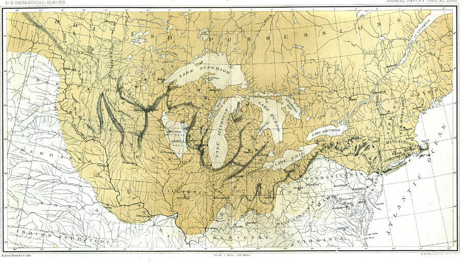
Description: A map from 1882 of the drift bearing area in the northern United States and Canada, showing the generalized directions of glacial movement, the direction of glacial striae, and the locations of prominent terminal moraines. Scale is one inch equals 150 miles, and referenced to Julius Bien and Co. lith. "The formation under consideration consists of an extensive belt of peculiarly ridged drift, stretching from the Atlantic in a sinuous course across the Northern States of the Union to Dakota, and thence onward into the British Possessions to an undetermined distance. It constitutes a broad, irregular range of confusedly heaped drift rather than a simple continuous ridge or group of definite parallel ridges, as has perhaps too often been the conception of a terminal moraine." — Chamberlin, 1882
Place Names: A Regional Map of North America, Canada, �United States, �Ottowa, �Quebec, �Augusta, �Boston, �Cape Cod, �Long Island Sound, �Buffalo, �Cleveland, �Indianapolis, �St Louis, �Madison, �Dubuque, �St Paul, �Des Moins, �Yankton,
ISO Topic Categories: boundaries,
geoscientificInformation,
inlandWaters,
oceans
Keywords: The Terminal Moraine Region of North America, physical, �political, �Driftless Area, �Limit of Drift, �Kettle Moraine, kGeology, kGlacial, physical features,
topographical, country borders,
major political subdivisions, boundaries,
geoscientificInformation,
inlandWaters,
oceans, Unknown, Second Glacial Epoch
Source: Thomas C. Chamberlin, United States Geological Survey Annual Report, 3rd (Washington, DC: United States Geological Survey, 1882) PL.XXVIII
Map Credit: Courtesy the private collection of Roy Winkelman |
|