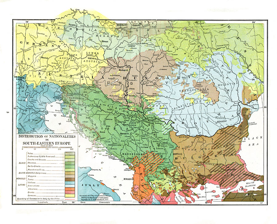
Description: This map shows nationalities in South–Eastern Europe during the WWI period of 1914–1918. Nationality is a matter of personal identity. Nationality could stem from the place of birth, the place where someone grew up, or where family is located or originates from. In World War I era South–Eastern Europe, nationalities can cross national borders, can define national borders, or many nationalities can be contained within one nation. One result of World War I was the dissolution of empires that contained multiple nationalities. This map defines areas of four main groups, the Slavs, Slavo–Mongols, Mongols, and Latins.
Place Names: Southeastern Europe, Romania, �Germany, �Greece, �Italy, �Poland, �Austria, �Hungary, �Austria-Hungary, �Czech Republic, �Slovakia, �Czechoslovakia, �Roumania, �Russia, �Bulgaria, �Albania, �Turkey, �Montenegro, �Bosnia-Hercegovina, �Croatia, �Croatia-Slavonia, �Serbia, �M
ISO Topic Categories: boundaries,
inlandWaters,
society
Keywords: Distribution of Nationalities in South–Eastern Europe, physical, �political, �statistical, �historical, �nationalities, kEthnic, physical features, country borders,
major political subdivisions, ethnological, WWI, boundaries,
inlandWaters,
society, Unknown, 1914–1918
Source: , The Victory Atlas of the War (New York, NY: Charles Scribner's Sons, 1918) 3
Map Credit: Courtesy the private collection of Roy Winkelman |
|
