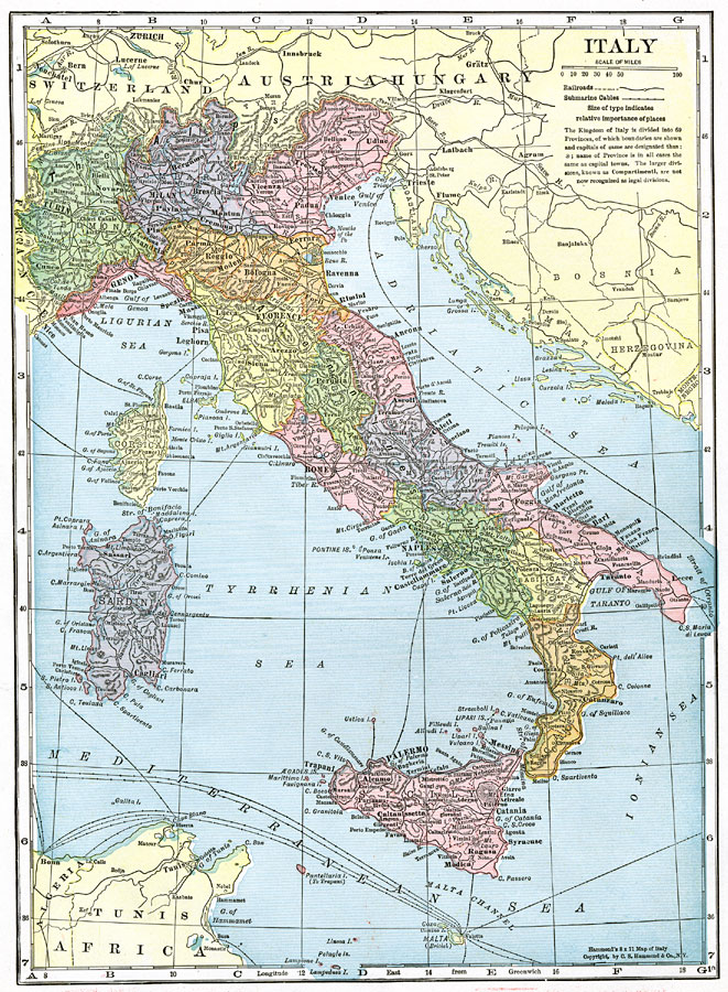
Description: A map of Italy in 1918, however, it shows the Italian provinces prior to the resolution of the Italian Irredentist Movement to unite the territories of ethnic Italians under the London Pact of 1915. This map shows the territories of Tyrol, Istria, and Dalmatia under Austria–Hungary Empire rule, Corsica under French, and Malta under British control. This map shows major cities, railways, submarine cables, rivers, terrain, and the provinces of the Kingdom of Italy at the time.
Place Names: Italy, Bologna, �Florence, �Genoa, �Messina, �Milan, �Naples, �Pisa, �Rome, �Venice, �Verona, �Sardinia, �Corsica, �Adriatic Sea, �Tyrrhenian Sea, �Mediterranean Sea, �Turin, �Torino,
ISO Topic Categories: boundaries,
inlandWaters
Keywords: Italy, physical, �political, �transportation, �historical, �submarine cables, �physical features, country borders, railroads,
water routes, WWI, boundaries,
inlandWaters, Unknown, 1918
Source: , The Victory Atlas of the War (New York, NY: Charles Scribner's Sons, 1918) 12
Map Credit: Courtesy the private collection of Roy Winkelman |
|