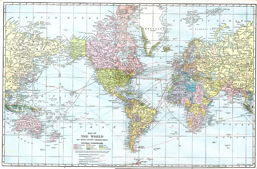
Description: This is a map of the world from 1918 showing the earth on a Mercator's Projection. This map is color–coded to show the colonial possessions of Great Britain, France, Germany, Portugal, Spain, Netherlands, Italy, Denmark, and the United States in Africa, Asia, and Oceania at the time, steamship routes (with distances between major ports given in nautical miles) with those passing through the Panama Canal in blue and other routes in red, principal through railways, principal wireless telegraph stations, and submarine cables. The map shows capitals, major cities and ports, rivers, islands, and coastal features.
Place Names: A Complete Map of Globes and Multi-continent, Africa, �Asia, �Australia, �Europe, �North America, �South Americ
ISO Topic Categories: boundaries,
inlandWaters,
transportation
Keywords: Map of The World on Mercator's Projection, physical, �political, �transportation, �historical, �steamship routes, �submarine cables, �telegraph stations, �shipping, �colonial possessions, �physical features, country borders, railroads,
water routes, WWI, boundaries,
inlandWaters,
transportation, Mercator, 1918
Source: , The Victory Atlas of the War (New York, NY: Charles Scribner's Sons, 1918) 16-17
Map Credit: Courtesy the private collection of Roy Winkelman |
|