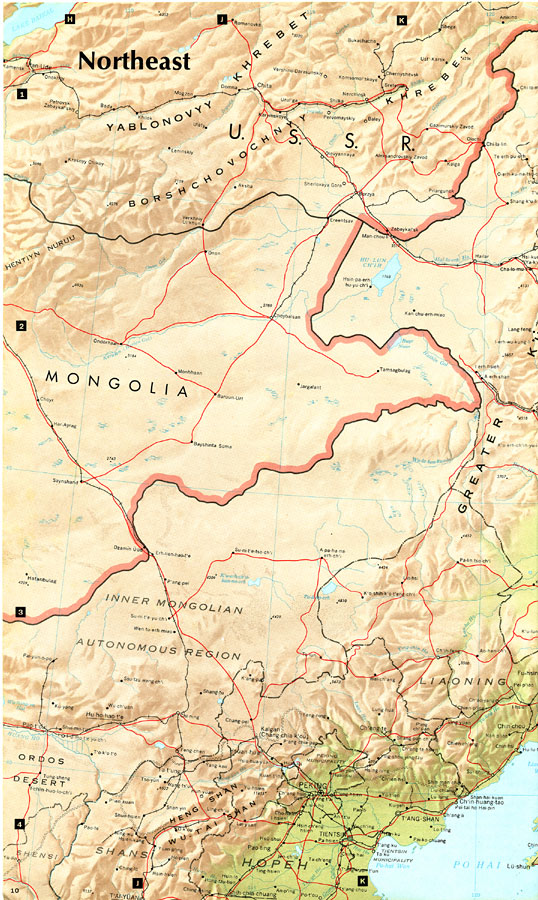
Description: "Northeast China — the provinces of Heilungkiang, Kirin, and Liaoning – is the most important region of the country and a nationally significant and still–developing center of agricultural production. Most of the Northeast remained largely unpopulated and unaffected by Han Chinese culture until about a century ago, although tenuous political ties with China had existed, specifically with the southernmost sector of the Manchurian Plain, from very early times. It was, in fact, a frontier region that often served as a base for nomadic invaders who periodically threatened, and at times controlled, parts of North China. The severe population pressures in North China during the 19th and 20th centuries, coupled with periods of Russian and Japanese development, provided the stimuli that finally led to settlement and modern economic development. The heart of this region is the extensive Northeast of Manchurian Plain, the largest in the country. Almost encircles by hills and low mountains, it opens only to Po Hai (Gulf of Chihli) in the southwest and though the restricted Sungari river valley to the frontier with the USSR in the northeast. Despite frequent spring droughts and a relatively brief growing season, the Manchurian Plain is highly productive agriculturally, and it is here that most of the region's population and economic activity is centered. The Greater and Lesser Khingan Ranges to the northwest, north, and northeast and the highland complex of hills and low mountains adjoining North Korea are economically important because of their extensive stands of timber and their important coal deposits. Northeast China contains the best–developed transportation net in the country. An extensive rail system — the densest in China — links all of the major population concentrations with regional market towns, major sources of industrial raw materials, and fuel resources. Through the initial development of the railroads dates to earlier periods of Russian and Japanese occupation, they have been substantially improved by the Chinese in recent years. Many of the old Japanese lines leading to the Soviet frontier have been rebuilt, a number of rail lines serving forestry areas have been expanded, and the capacity of the basic rail net has been increased. Though more localized, the Sungari river is a regionally important means of transporting forest and agricultural products. As the primary industrial region in China, the Northeast owes its national importance to its superior transportation system, extensive raw materials and energy sources, as well as to accidents of history. Most of its extensive industrial development has taken place during this century, much of it prior to 1945 and under the auspices of foreign industrial firms. The Chinese have reconstructed and further developed the industrial base, however, capitalizing at times on help provided by friendly nations. A recent major development is the much–heralded and nationally preeminent Tach'ing oilfield and refinery, located in the northern part of the Manchurian Plain. Other extensive mineral deposits in the Northeast include large coal deposits. Coal is mined in huge open pits, as at Fu–shun and Ho–kang, and in large underground complexes such as those in the Shung–ya–shan area. Other mineral resources include large, relatively low–grade iron ore deposits around Anshan, the major iron and steel center in China, and in southwestern Liaoning there are sizable deposits of molybdenum and smaller deposits of manganese and other important ferroalloys. Though magnesite is found in abundance in southern Liaoning, most other mineral deposits, such as copper and lead, are relatively small. Important hydroelectric power resources exist, particularly on the Yalu and Sungari rivers, where several major dams and reservoirs have been built. Though Northeast China's population is now overwhelmingly Han Chinese and integrated into the national economy, there are important minorities, particularly of Korean farmers who live in valleys close to the Korean border. A few Mongol groups live partially within and to the west of the Greater Khingan Range. Manchus, once numerous, are now largely absorbed within Chinese culture. Though only a few Russians remain, they left an architectural imprint on the northeastern cities that is visible in the bulbous spires of the Eastern Orthodox Churches. However, they, like the Japanese, left their most important legacy in the form of an impressive industrial and transportation complex." — CIA, 1971.
Place Names: China, Beijing, �Peking, �Fu-Shun, �Ch'un, �Ha-ern-pi
ISO Topic Categories: society,
transportation
Keywords: Northeast China, transportation, �physical, �political, physical features,
topographical, country borders, roads,
railroads, society,
transportation, Unknown, 1971
Source: Central Intelligence Agency, People's Republic of China Atlas (Washington, DC: U.S. Government Printing Office, 1971) 10
Map Credit: Courtesy the private collection of Roy Winkelman |
|