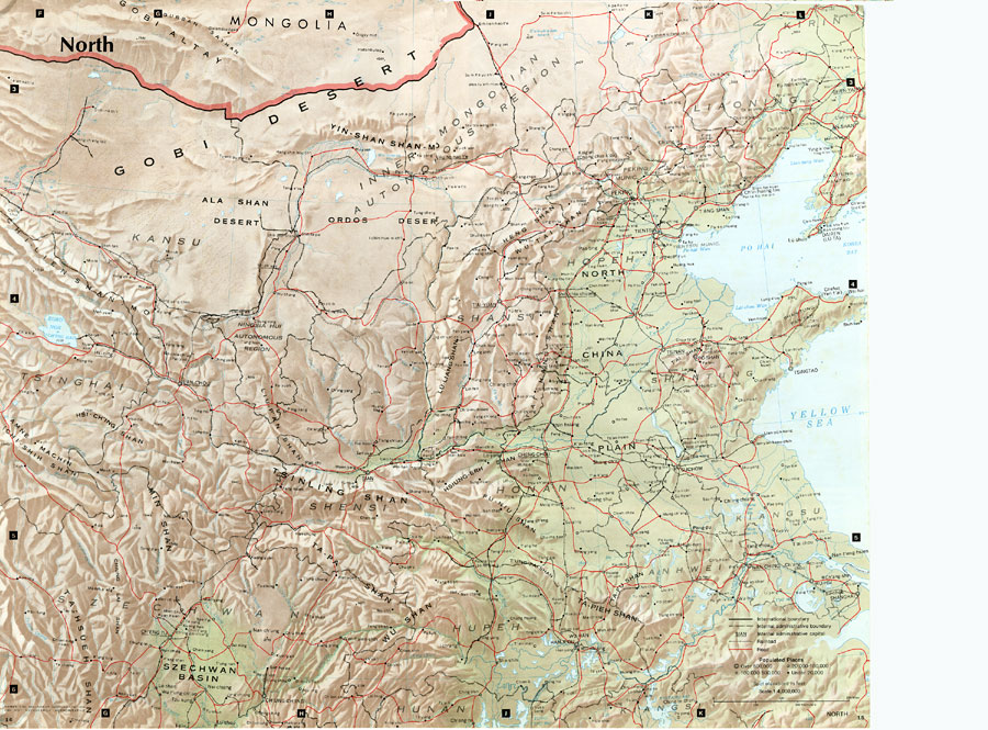
Description: " North China includes the densely populated and intensively cultivated North China Plain, the loess–covered uplands of Shansi, northern Shensi, and eastern Kansu, and the sparsely populated, semiarid steppes of Inner Mongolia. Historically, often-hostile nomadic groups surged across the steppe to threaten and occasionally invade the prosperous cities and adjoining rural districts of North China. Separating these two distinct worlds — the grasslands from intensively cultivated valleys and plains — is the Great Wall. The Wall, actually a series of walls built at different times, was constructed by the Chinese to limit and control contact between themselves and the " barbarians " of the steppes. Ancient Chinese civilization began in the Wei Ho Valley and in contiguous areas of present day Shensi, Shansi, and Honan; in time it gradually expanded to incorporate the North China Plain. Fertile and easily tilled soil, extensive plains, and an adequate climate (at times marginal in terms of rainfall) proved conducive to the development of intensive forms of agriculture and relatively high population densities. The North has been the politically and culturally dominant region of China throughout most of history, although recurrent droughts, floods, famines, and periodic invasions from the northern steppes have from time to time shifted the political and economic base southward to the middle and lower Yangtze regions. The advantages of the North have in recent years been reasserted and its primacy has been reinforced by a homogeneous Han Chinese population that shares a common culture and language, terrain that is suitable for road and rail construction, and the mineral and power resources needed by modern industry. Major industrial districts in North China are located in a triangle formed by the cities Peking, T'ang–shan, and Tientsin; at T'aiyuan; in northern Honan at Cheng–chou and Lo–yang; and at Paot'ou. Iron and steel, agriculture machinery, and textiles are some of the major products. Plentiful supplies of coal, located at numerous mines that rim the North China Plain, are available; major iron ore deposits also occur. West of the North China Plain are the physically diverse lands of Shensi, Shansi, and eastern Kansu, where almost everywhere landforms are blanketed by thick layers of fine–grained, yellow leossial (wind deposited) soils. The characteristic landscape is one of steep–sided valleys, gullies, and cliffs, often contoured into even more intricate forms by man–made terraces. The favorable physical environment in the loess area nurtured early civilization, but continuous settlement led to the gradual destruction of the original cover of grass and forest. Population pressures increased the need for timber and for additional land to till, thereby accelerating the physical degradation of a soil highly susceptible to erosion. The loesslands today are bleak and harsh, overpopulated, and continually threatened by droughts and crop failure..." — CIA, 1971.
Place Names: China, Tsinan, �shan, �shensi, �wu shan, �Gobi Desert, �Shansi, �Kiangsu, �Hona
ISO Topic Categories: society,
transportation
Keywords: North China, physical, �political, �transportation, physical features,
topographical, country borders, roads,
railroads, society,
transportation, Unknown, 1971
Source: Central Intelligence Agency, People's Republic of China Atlas (Washington, DC: U.S. Government Printing Office, 1971) 6
Map Credit: Courtesy the private collection of Roy Winkelman |
|