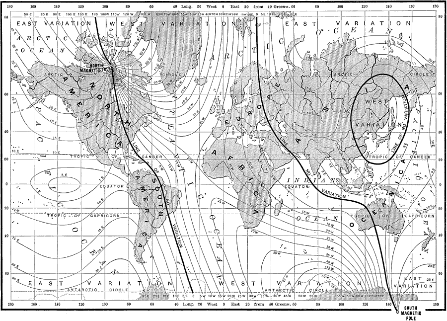
Description: A world map from 1890 showing the Earth's east-west declination of the magnetic poles from the geographic poles. In order to properly read a compass, variations in the location of magnetic north from the observer's current location must be taken into consideration. "By consulting the map, it will be seen at once that the points designated as magnetic poles do not coincide with the geographical poles. It will also be observed that a line passes through the north magnetic pole, which south of that point is marked 0°, and north of it 180°. This means that anywhere along this line there is no declination of the needle, and that in the high latitudes of North America the north pole of the needle points to the south. To the east of this line in North and South America, the needle points west of north. The variation increases rapidly in the high latitudes of North America; but after reaching 25° to 30° it gradually diminishes in the Eastern Hemisphere until another line of no variation is reached, which passes through Europe, Eastern Asia, and Australia. The declination of the needle is then east of north, and gradually increases till a third line is reached, along which the needle does not vary. This line is nearly oval in shape, and includes Japan. Within its limits the declination is west. From this point the variation is again easterly till the first line of no variation is reached." — Brewer, 1890, p. 26.
Place Names: A Complete Map of Globes and Multi-continent, Africa, �Antarctica, �Asia, �Australia, �Europe, �North America, �South America, �Pacific Ocean, �Atlantic Ocean, �Indian Ocean,
ISO Topic Categories: geoscientificInformation
Keywords: Magnetic Chart of the World, physical, �magnetic fields, �magnetic poles, �magnetic charts, �physical features, geoscientificInformation, Unknown, 1890
Source: William H. Brewer Ph.,D., Warren's New Physical Geography (Philadelphia, PA: Cowperthwait and Company, 1890) 26
Map Credit: Courtesy the private collection of Roy Winkelman |
|