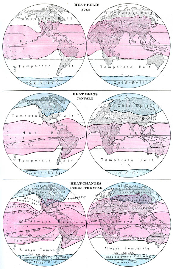
Description: This is a map from 1898 showing seasonal worldwide heat belts during July (top) and January (middle), with a combined map showing overall heat changes during the year (bottom). "The boundaries of the true heat belts in January and in July are shown...Each boundary line is an isotherm; that is, a line passing through places having the same temperature. The boundary of the cold belt has about the temperature of freezing water (30°[F]); that of the hot belt has the comfortable temperature of a sitting room (70°[F]." —Redway, 1898.
Place Names: A Complete Map of Globes and Multi-continent, Temperate Belt, �Hot Belt, �Cold Belt, �July, �January, �Heat Equator July, �Heat Equator Januar
ISO Topic Categories: climatologyMeteorologyAtmosphere
Keywords: Climate, True Heat Belts, meteorological, �historical, kClimate, climate, climatologyMeteorologyAtmosphere, Unknown,1898
Source: Jacques W. Redway and Russell Hinman, Natural Advanced Geography (New York, NY: American Book Company , 1898) 25
Map Credit: Courtesy the private collection of Roy Winkelman |
|