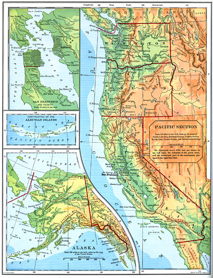
Description: A map from 1898 of the Pacific region of the United States. The map is color&ndas;coded to show highlands above 2000 feet in buff tints, lowlands in green, and the submerged part of the continental plateau in light blue. Inset map detail the San Francisco Bay, the western Aleutian Islands, and Alaska. "Alaska is almost as large as Washington, Oregon, California, and Texas taken together, and yet it does not contain so many people as the city of Oakland. The southern coast of Alaska is very rough and mountainous. Some of the peaks of these mountain ranges are over three miles high; they are they highest in North America. These mountains prevent the warm, moist winds of the Pacific from reaching the interior, which is consequently very cold during the greater part of the year. Part of the interior is covered with open forests, but much of it is a bleak tundra. The southern slopes of the mountains are much warmer, receive abundant rains, and are covered with forests. The summits of the mountains are always snow-clad. Great glaciers creep down most of the larger valleys, many of them extending to the sea. Nearly all of the people live near the southern coast...Some hardy vegetables grow in this region, but it is too damp for grain. The chief occupations are hunting fur-bearing animals, fishing for cod and salmon, and gold-mining." &mdashRedway, 1898.
Place Names: Pacific States, Juneau, �Sitka, �Mt. St. Elias, �Alaskan Mountains, �Yukon Hills, �Cook Inlet, �Douglas, �Pacific Ocean, �Bering Strait, �Aleutian Islands, �Artic Ocean, �Asia, �Canad
ISO Topic Categories: boundaries,
elevation,
oceans,
inlandWaters
Keywords: The Pacific States, physical, �political, �historical, physical features,
topographical, country borders,
major political subdivisions, boundaries,
elevation,
oceans,
inlandWaters, Unknown,1898
Source: Jacques W. Redway and Russell Hinman, Natural Advanced Geography (New York, NY: American Book Company , 1898) 88
Map Credit: Courtesy the private collection of Roy Winkelman |
|