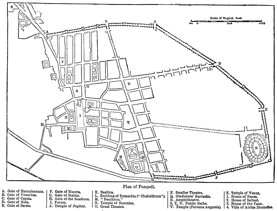
Description: A map of Pompeii showing Gate of Herculaneum (A), Gate of Vesuvius (B), Gate of Capua (C), Gate of Nola (D), Gate of Sarno (E), Gate of Nocera (F), Gate of Sabiae(G), Gate of the Seashore (H), Forum (I), Temple of Jupiter (J), Basilica (K), Building of Eumachia ("Chalcidicum") (L), "Pantheon" (M), Temple of Hercules (N), Great Theatre (O), Smaller Theatre (P), Gladiators' Barracks (Q), Amphitheatre (R), Public Baths (S), Public Baths (T), Public Baths (U), Temple (Fortuna Augusta) (V), Temple of Venus (X), House of Pansa (1), House of the Sallust (2), House of the Faun (3), and Villa of Arrius Diomedes (4). "The town was situated on a rising ground of small elevation, separated by a distance of less than a mile from the foot of the actual rise of the outer cone of Vesuvius. This eminence is itself, undoubtedly due to an outflow of lava from that mountain, during some previous eruption in prehistoric times, for we know from Strabo that Vesuvius, though presenting in his time all the appearances of an extinct volcano, had been quiescent ever since the first records of the Greek settlements in this part of Italy. The area occupied by the ancient city was of an irregular oval form, and about two miles in circumference. It was surrounded by a wall, which is still preserved around more than two-thirds of its extent, but no traces of this are found on the side towards the sea, and there is no doubt that on this side it had already been demolished in ancient times, so as to give room for the free extension of houses and other buildings in that direction. These walls are strengthened at intervals by numerous towers, which occur in some parts at a distance of only about 100 yards, but in general much less frequently." (—Kellogg, 1903)
Place Names: Italy, Pompeii,
ISO Topic Categories: boundaries,
society,
structure
Keywords: Plan of Pompeii, physical, �political, �city structure, �physical features, local jurisdictions, boundaries,
society,
structure, Unknown,A.D. 79
Source: Day Otis Kellogg, D.D., Encyclopedia Britannica Vol. XIX (New York, NY: The Werner Company, 1903) 446
Map Credit: Courtesy the private collection of Roy Winkelman |
|