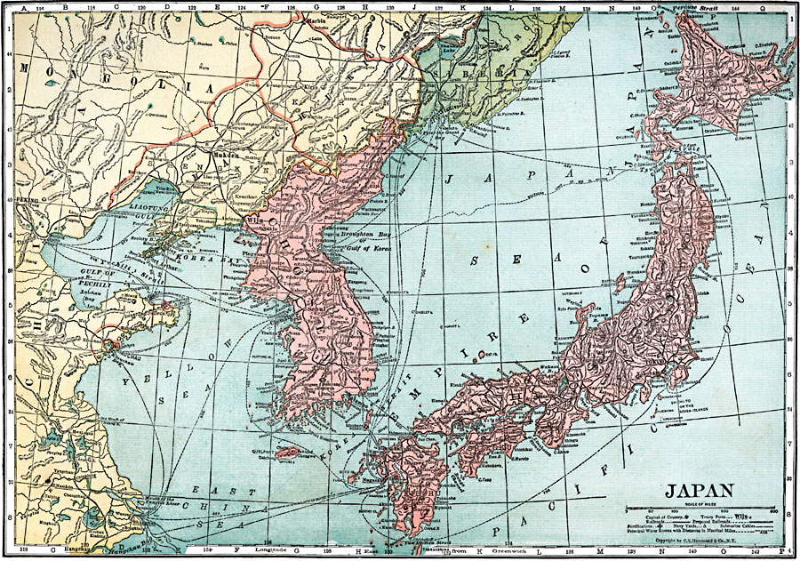
Description: A map from 1920 of Japan, showing the islands of Yesso (Hokkaido), Hondo (Honshu), Shikoku, and Kiushu (Kyushu), the capital city (Tokyo) and other major cities, treaty ports, railroads, proposed railroads, submarine cables, fortifications, and navy yards. Principal steamship routes are shown with distances between ports given in nautical miles. This map shows Chosen (Korea) as a Japanese possession, and the frontiers of the Russian Empire and China, with foreign possessions in China (Port Arthur, Weihaiwei, Kiauchau). The southern limit of ice in winter is shown, highlighting the importance of the warm–water port of Port Arthur to the Russians.
Place Names: Japan, Tokyo, �Yokohama, �Perouse, �Morovan, �Hakodate, �Wayima, �Nagoya, �Osaka, �Hiroshima, �Nagasaki, �Miyazaki, �Fukuoka, �Hagi, �Fukuchiyama, �Shizuok
ISO Topic Categories: boundaries,
inlandWaters,
location,
oceans,
transportation,
utilitiesCommunication
Keywords: Japan, physical, �political, �transportation, physical features, country borders,
major political subdivisions, railroads, boundaries,
inlandWaters,
location,
oceans,
transportation,
utilitiesCommunication, Unknown, 1920
Source: , Leslie's New World Atlas (New York City, NY: Leslie-Judge Company, 1920) 27
Map Credit: Courtesy the private collection of Roy Winkelman |
|