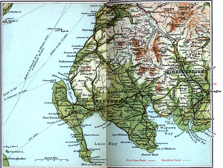
Description: A detailed travel map of southwestern Scotland from 1908, showing portions of Kirkcudbright and Wigtown counties. The map shows first class and secondary roads, railways, cities, towns, ports, ferry routes, rivers, lakes, terrain and coastal features of the area. This map uses contour–coloring to show terrain, with elevations shown in feet. Cities and towns on this map include Girvan, New Galloway, Castle Douglas, Kirkcudbright, Whithorn, Wigtown, Ballantrae, Port Patrick, and Stranraer. Rivers, lakes, and coastal features include River Dee, River Cree, Loch Ryan, Loch Doon, Wigtown Bay, Luce Bay, Burrow Head, Mull of Galloway, and the mountains Merrick, Alwat, and Kells Range.
Place Names: United Kingdom, Carrick, �Castle Douglas, �Kirkcudbright, �New Galloway, �Stranraer, �Wigtow
ISO Topic Categories: inlandWaters,
location,
oceans,
transportation
Keywords: Wigtown and Kirkcudbright, roads, �transportation, roads, inlandWaters,
location,
oceans,
transportation, Unknown, 1908
Source: J.G. Bartholomew, F.R.G.S., The Handy Touring Atlas of the British Isles Specially Prepared for Cyclists, Motorists, and Travellers (London, United Kingdom : George Newnes, Limited, 1908) 58-59
Map Credit: Courtesy the private collection of Roy Winkelman |
|