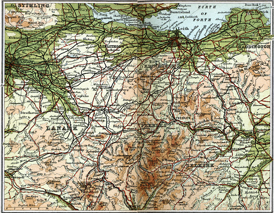
Description: A detailed travel map of Scotland from 1908, showing portions of counties Stirling, Linlithgow, Edinburgh, Haddington, Lanark, Peebles, and Selkirk. The map shows first class and secondary roads, railways, cities, towns, ports, rivers, lakes, terrain and coastal features of the area. This map uses contour–coloring to show terrain, with elevations shown in feet. Cities on this map include Glasgow, Edinburgh, Bathgate, Haddington, Melrose, Peebles, Lanark, Sanquhar, Selkirk, and Moffat. Rivers and coastal features include River Nith, Douglas Water, River Forth, Firth of Forth, Bass Rock, and the mountains Hart Fell, Brbad Law, Campsie Fells, Pentland Hills, and Moorfoot Hills.
Place Names: United Kingdom, Edinborough, �Glasgow, �Haddington, �Lanark, �Linlithgow, �Peebles, �Selkirk, �
ISO Topic Categories: inlandWaters,
location,
oceans,
transportation
Keywords: Edinburgh and Glasgow, roads, �transportation, roads, inlandWaters,
location,
oceans,
transportation, Unknown, 1908
Source: J.G. Bartholomew, F.R.G.S., The Handy Touring Atlas of the British Isles Specially Prepared for Cyclists, Motorists, and Travellers (London, United Kingdom : George Newnes, Limited, 1908) 62-63
Map Credit: Courtesy the private collection of Roy Winkelman |
|