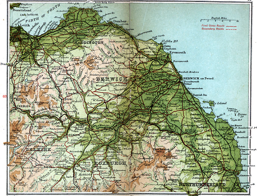
Description: A detailed travel map of southeastern Scotland from 1908, showing portions of counties Edinburgh, Haddington, Peebles, Selkirk, and Roxburgh. A portion of Northumberland (England) north of Rothbury is shown. The map shows first class and secondary roads, railways, cities, towns, ports, battlefields, rivers, lakes, terrain and coastal features of the area. This map uses contour–coloring to show terrain, with elevations shown in feet. Cities on this map include Edinburgh, Haddington, Dunbar, Eyemouth, Berwick on Tweed, Melrose, Peebles, Kelso, Jedburgh, Selkirk, and Hawick. Rivers and coastal features include River Tweed, River Whiteadder, River Teviot, Firth of Forth, Bass Rock, Farne Isle, and the mountains The Cheviot, Dun Rig, Lammermuir Hills, and Moorfoot Hills.
Place Names: United Kingdom, Berwick, �Haddington, �Lammermuir Hills, �Northumberland, �Roxburgh, �Selkir
ISO Topic Categories: inlandWaters,
location,
oceans,
transportation
Keywords: Haddington & Berwick, roads, �transportation, roads, inlandWaters,
location,
oceans,
transportation, Unknown, 1908
Source: J.G. Bartholomew, F.R.G.S., The Handy Touring Atlas of the British Isles Specially Prepared for Cyclists, Motorists, and Travellers (London, United Kingdom : George Newnes, Limited, 1908) 64-65
Map Credit: Courtesy the private collection of Roy Winkelman |
|