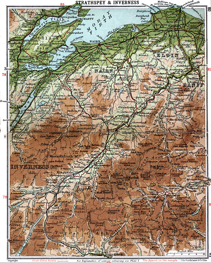
Description: A detailed travel map of central Scotland from 1908, showing Nairn, Elgin, and portions of Banff and Inverness counties. The map shows first class and secondary roads, railways, cities, towns, ports, ferry routes, rivers, lakes, terrain and coastal features of the area. This map uses contour–coloring to show terrain, with elevations shown in feet. Cities and towns on this map include Elgin, Nairn, Cromarty, Beauly, Inverness, Dufftown, Grantown, Kingussie, and Blair Athol. Rivers, lakes, and coastal features include River Nairn, River Findhorn, River Spey, River Avon, River Fleshie, Loch Ness, Cromarty Firth, Beauly Firth, Moray Firth, and the mountains Lochnagar, Ben Dearg, Beinn–a–Bhnird, Ben Macdhui, and the Monadhlaith Mountains.
Place Names: United Kingdom, Badenoch, �Banff, �Dingwall, �Elgin, �Forest of Atholl, �Inverness, �Nairn, �Strathspe
ISO Topic Categories: inlandWaters,
location,
oceans,
transportation
Keywords: Strathspey and Inverness, roads, �transportation, roads, inlandWaters,
location,
oceans,
transportation, Unknown, 1908
Source: J.G. Bartholomew, F.R.G.S., The Handy Touring Atlas of the British Isles Specially Prepared for Cyclists, Motorists, and Travellers (London, United Kingdom : George Newnes, Limited, 1908) 80-81
Map Credit: Courtesy the private collection of Roy Winkelman |
|