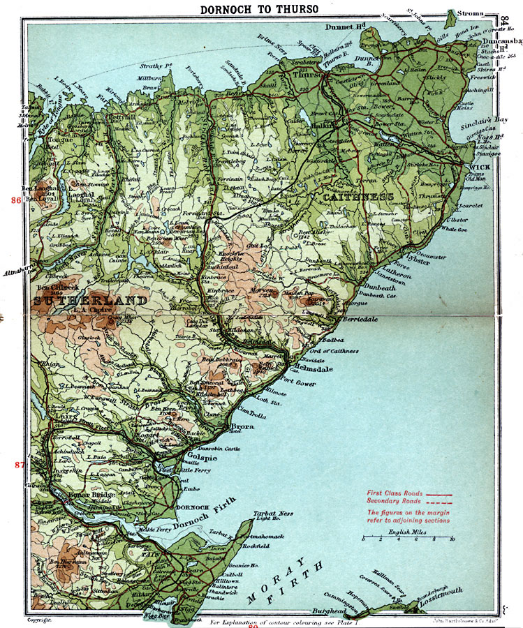
Description: A detailed travel map of Scotland from 1908, showing portions of counties Sutherland and Caithness. The map shows first class and secondary roads, railways, cities, towns, ports, rivers, lakes, terrain and coastal features of the area. This map uses contour–coloring to show terrain, with elevations shown in feet. Cities on this map include Tain, Lairg, Dornoch, Helmsdale, Wick, and Thurso. Rivers, lakes and coastal features include Strath Brora, Strath Naver, River Helmsdale, Loch Calder, Loch Naver, Kyle of Tongue, Dunnet Head, Dornoch Firth, and Moray Firth, and the mountains Ben Horn, Craig Mhor, Ben Clibreck, Ben Laoghal, Scaraven, and Ben Smeoral.
Place Names: United Kingdom, Brora, �Caithness, �Dornoch Firth, �Golspie, �Sutherland, �Thurso, �Wic
ISO Topic Categories: inlandWaters,
location,
oceans,
transportation
Keywords: Dornoch to Thurso, roads, �transportation, roads, inlandWaters,
location,
oceans,
transportation, Unknown, 1908
Source: J.G. Bartholomew, F.R.G.S., The Handy Touring Atlas of the British Isles Specially Prepared for Cyclists, Motorists, and Travellers (London, United Kingdom : George Newnes, Limited, 1908) 84-85
Map Credit: Courtesy the private collection of Roy Winkelman |
|