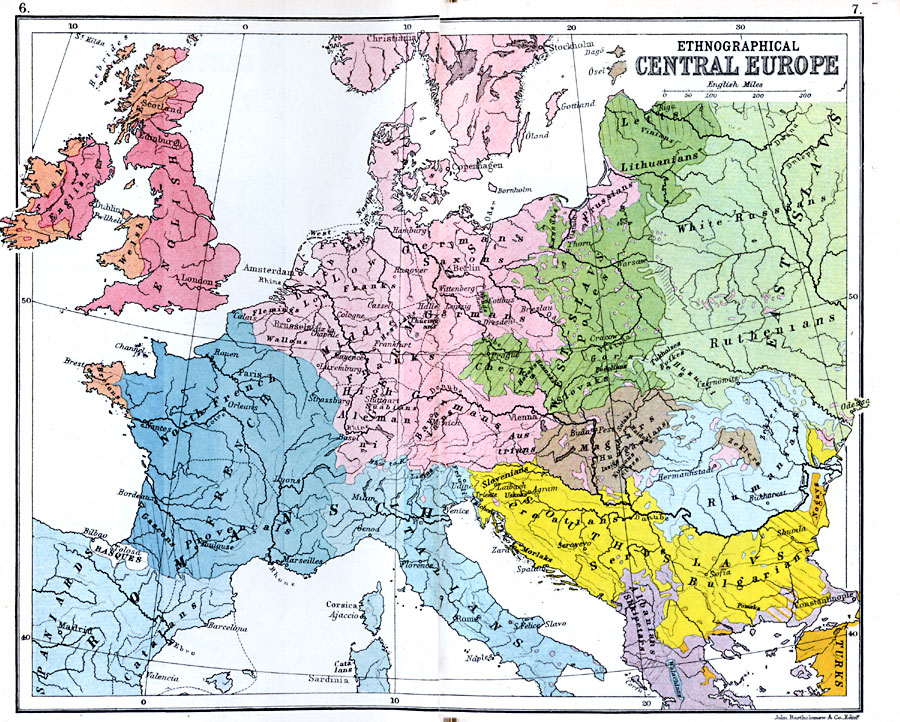
Description: A color–coded map showing the ethnographical features of Central Europe in 1910, including the English, Welsh, Irish, and Erse of the British Isles, Basques and Catalans in Spain, Gascons, Provincials, and Bretons in France, Danes, Frisians, Dutch, Flemings, Low Franks, Prussians, and Saxons in Lower Germany, Wallons and Franks in Middle Germany, Alemani, Bavarians, and Austrians in High Germany, Italians, Letts, Lithuanians, Kassubs, Poles, Checks, Slovaks, Heraks, Hannaks, and Podolians in the West Slavs, White Russians, Ruthenians, Tukhalzes, Boikes, and Huzuli in the East Slavs, Slovenians, Uskoks, Croations, Morlaks, Serbs, Norgays, Bulgarians, and Pomaks in the South Slavs, Sotaks, Haiduks, Iazigs, Kumans, and Zeklers in Magyar (Hungary), Rumanians and Rumani Zeklers, Albainians, and Walachians. This map also shows major cities and rivers in Central Europe.
Place Names: Western and Central Europe, Austria, �France, �Germany, �Greece, �Italy, �Romania, �Spain, �Turkey, �United Kingdo
ISO Topic Categories: inlandWaters,
location,
oceans
Keywords: Ethnographical Central Europe, physical, �physical features, �ethnographical, �statistical, kEthnic, physical features, ethnological, inlandWaters,
location,
oceans, Unknown, 1910
Source: J.G. Bartholomew, LLD, A Literary & Historical Atlas of Europe (New York, NY: E.P. Dutton & Co., Ltd. , 1910) 6-7
Map Credit: Courtesy the private collection of Roy Winkelman |
|