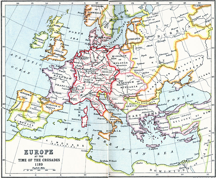
Description: A map of Europe in 1189 at the time of the Third Crusade. This map shows the West Roman Empire at the time, including the territories of Holland, Frisia, Westphalia, Holsatia, Saxonia, Slavinia, Pomerania, Brabant, Hassia, Brandenburg, Misnt, Lusatia, Lotharingia, Francia, Suevia, Bavaria, Bohemia, Moravia, Austria, Styria, Burgundia, Arelate, Langobardia, Carinthia, Aquileia, Tuscia, Romandiola, Corsica, Sardinia, and St. Petri. This map also shows the southern portions of the Kingdom of Norwegia, and the Kingdom of Suecia (Norway and Sweden), Esthonia, Lithuania, Kingdom of Denmark, Scotia, Hibernia, Gaullia, Anglia, Kingdom of Polania, Kingdom of Hungaria, Kingdom of Francia, Kingdom of Leon, Kingdom of Portugal, Kingdom of Castilia, Kingdom of Navarre, Kingdom of Aragon, Venicia, Kingdom of Sicilia, Servia, and the East Roman or Byzantine Empire. The map shows the territories of the Pruzzians, Yatvegs, Polosk, Novgorod, Mordvins, Cumans or Polovzians, Khazars, Alans, and Bulgarians, and the Moslem territories of the Seljuks of Rum, Armenia Minor, Dominions of Salad, and the territory of the Almohads (Muwahhids) in northern Africa and the southern Iberian Peninsula. Major rivers and important cities of the time are also shown.
Place Names: Western and Central Europe, Bulgaria, �France, �Hungary, �Poland, �Roman Empire, �Russia, �West Roman Empire, Holland, Frisia, Westphalia, Holsatia, Saxonia, Slavinia, Pomerania, Brabant, Hassia, Brandenburg, Misnt, Lusatia, Lotharingia, Francia, Suevia, Bavaria, Bohemia, Moravia, Austria, Styria, Burgundia, Arelate, Langobardia, Carinthia, Aquileia, Tuscia, Romandiola, Corsica, Sardinia, St. Petri, Kingdom of Norwegia, Kingdom of Suecia, Esthonia, Lithuania, Kingdom of Denmark, Scotia, Hibernia, Gaullia, Anglia, Kingdom of Polania, Kingdom of Hungaria, Kingdom of Francia, Kingdom of Leon, Kingdom of Portugal, Kingdom of Castilia, Kingdom of Navarre, Kingdom of Aragon, Venicia, Kingdom of Sicilia, Servia, Byzantine Empire, Pruzzians, Yatvegs, Polosk, Novgorod, Mordvins, Cumans, Polovzians, Khazars, Alans, Bulgarians, Seljuks of Rum, Armenia Minor, Dominions of Salad, Almohads, Muwahhids
ISO Topic Categories: inlandWaters,
location,
oceans
Keywords: Europe at the Time of the Crusades, country borders, �political, kCrusades, country borders, inlandWaters,
location,
oceans, Unknown, A.D. 1189
Source: J.G. Bartholomew, LLD, A Literary & Historical Atlas of Europe (New York, NY: E.P. Dutton & Co., Ltd. , 1910) 20-21
Map Credit: Courtesy the private collection of Roy Winkelman |
|