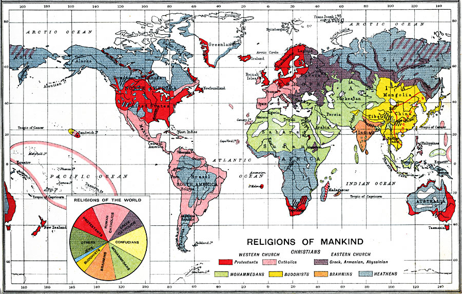
Description: A map from 1915 showing the religious regions of the world. The map is color–coded to show the regions of predominately Protestant, Catholic, Eastern Church (Greek, Armenian, Abyssinian), Mohammedan, Buddhist, Brahmin, and Heathen religions, with the area of predominately Confusion influence noted. A pie–chart graphically shows the world–wide distribution of religions in 1915.
Place Names: A Complete Map of Globes and Multi-continent, South America, �North America, �Europe, �Australia, �Asia, �Antarctica, �Afric
ISO Topic Categories: inlandWaters,
oceans,
location,
boundaries,
society
Keywords: Religions of Mankind, physical, �political, �borders, �statistical, �religion, �society, ����physical features, country borders, inlandWaters,
oceans,
location,
boundaries,
society, Unknown, 1915
Source: J.G. Bartholomew, A School Economic Atlas (London, England: Oxford University Press, 1915) 13
Map Credit: Courtesy the private collection of Roy Winkelman |
|