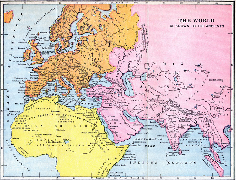
Description: A map of the world known to Europeans prior to the sailing explorations of the Portuguese and Spanish toward the end of the fifteenth century. The map shows Europe in orange, Asia in pink, and Africa in yellow. Place names are labeled in common Latin form. Major seas include Oceanus Atlanticus (Atlantic), Indicus Oceanus (Indian Ocean), Mare InInternum (Mediterranean), Oceanus Germanicus (North Sea), Sinus Codanus (Baltic Sea), Mare Adriaticum (Adriatic Sea), Pontus Euxinus (Black Sea), Caspium or Hyrcanum Mare (Caspian Sea), Sinus Arabicus (Red Sea), Sinus Persicus (Persian Gulf), Erythræum Mare (Arabian Sea), and Gangeticus Sinus (Bay of Bengal). Major rivers include the Ister (Danube), Danaster (Dniester), Borysthenes (Dneiper), Rha (Volga), Nilus (Nile), Euphrates, Oxus, Indus, Ganges, and Bautisus (Yellow or Hoang–ho).
Place Names: Regional Miscellaneous, Africa, �Asia, �Europ
ISO Topic Categories: historical, �political, �water routes, kWorldMedSea, kWorldAfroAsia, kWorldEurasia, kWorldEuroAfrica
Keywords: The World as Known to the Ancients, historical, �political, �water routes, ��country borders, historical, �political, �water routes, kWorldMedSea, kWorldAfroAsia, kWorldEurasia, kWorldEuroAfrica, Unknown, Circa 512 BC
Source: Victor Duruy, Edwin A. Grosvenor, & Louis E. Van Norman, Duruy's General History of the World (vol. I) (New York, New York: The Review of Reviews Company, 1912)
Map Credit: Courtesy the private collection of Roy Winkelman |
|