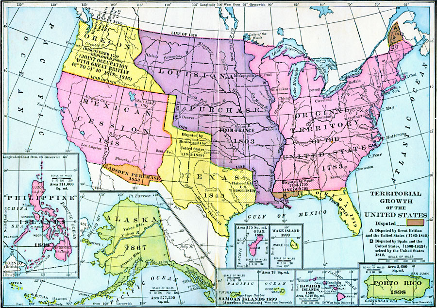
Description: A map from 1911 of the United States showing the territorial acquisitions from the original states and territory established in 1783 to the Tripartite Convention of 1899 in which Germany and the United States divided the Samoan Archipelago. This map shows the original territory acquired after the American Revolution, territories acquired under the Louisiana Purchase in 1803, the disputed territory of West Florida between 1803 and 1819, the purchase of the Florida territories from Spain in 1819, the Texas annexation in 1845, Oregon Country in 1846, the Mexican territories ceded in 1848, the Gadsden Purchase in 1853, the Alaska Territory purchased from Russia in 1846, the territories of Puerto Rico, Guam, and Philippine Islands acquired after the Spanish–American War in 1898, the annexation of Hawaii under the Newlands Resolution of 1898, Wake Island in 1899, and American Samoa under treaty with the Germans in 1899.
Place Names: Growth of Nation, Boston, �Chicago, �Houston, �Los Angeles, �Miami, �New Orleans, �New York, �San Diego, �Seattle, �Washington D.C
ISO Topic Categories: location,
oceans,
inlandWaters,
boundaries
Keywords: Territorial Growth of the United States, borders, �historical, �political, �country borders,
county borders, historical event, location,
oceans,
inlandWaters,
boundaries, Unknown, 1783–1900
Source: John Clark Ridpath , History of the United States from Aboriginal Times to Taft's Administration (vol. 2) (New York, NY: The Review of Reviews Company, 1911)
Map Credit: Courtesy the private collection of Roy Winkelman |
|
