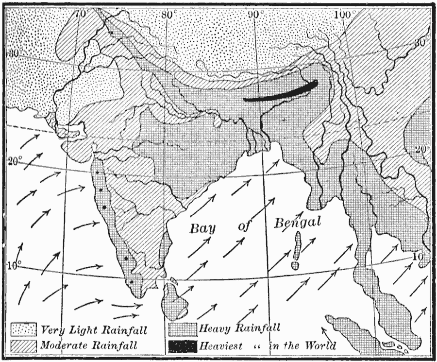
Description: A map from 1910 of the Indian subcontinent and the Central Asia region showing the typical rainfall distribution patterns during the summer monsoons, keyed to show areas of rainfall ranging from very light to, according to this text, the heaviest in the world in northern Bengal. The map shows the prevailing wind direction during the season, with the winds blowing from the Indian Ocean and Bay of Bengal toward the continent. "The sea breezes blow only for short distances. But when a large body of land, like a continent, becomes warm, air from the cooler ocean may blow toward it for hundreds of miles. In winter, on the other hand, when the land becomes cooler than the ocean, the cold air over a vast area may move toward the sea. Such winds exist in Mexico and our Gulf States; but they are far more important in Asia. The interior of that vast continent is so far from the ocean, that there are naturally great changes in temperature from summer to winter. During the winter, the heavy air over the cold land settles down as drying air, and presses outward beneath the warmer air which lies over the ocean. This produces dry winds from the land. In summer, on the other hand, the air over the cool water crowds in, raises the heated air of the continent, and produces ocean winds and rain. Winds which thus blow in opposite directions in different seasons, are better developed in India than in any other part of the earth; and it was here that they received the name, monsoon winds. [...] The rainy season comes in India when the summer monsoons blow; and the rainfall is especially heavy where the moisture–laden air rises up the steep slopes of the Himalayas. Indeed, the region north of the Bay of Bengal receives the heaviest rainfall of any part of the earth. Here, in the month of July alone, there is three times as much rain as falls in the eastern part of the United States during the entire year." — Tarr and McMurry, 1910, pp. 217–218.
Place Names: India ,
ISO Topic Categories: boundaries,
oceans,
location,
inlandWaters,
climatologyMeteorologyAtmosphere
Keywords: Summer Monsoon in India, physical, �meteorological, kClimate, physical features, winds,
rainfall, boundaries,
oceans,
location,
inlandWaters,
climatologyMeteorologyAtmosphere, Unknown, 1910
Source: Ralph S. Tarr, B.S., F.G.S.A. and Frank M. McMurry, Ph.D., New Geographies 2nd ed (New York, NY: The Macmillan Company, 1910) 217
Map Credit: Courtesy the private collection of Roy Winkelman |
|
